1960s Maps of Yawkey, West Virginia
Explore 2 historic maps of Yawkey from the 1960s. These maps offer a rare glimpse into what life looked like during the 1960s — showing old roads, neighborhoods, homes, and landmarks that have changed or disappeared over time.
Whether you're researching your family's past, planning a metal detecting trip, or studying how Yawkey's landscape evolved across the 1960s, these high-resolution maps are a powerful tool for exploring the history of this region.
- Focus on a specific era: All maps on this page are from the 1960s, giving you a focused view of this time period.
- See what’s changed: Compare century-old streets, trails, and buildings to today's modern landscape using overlays and satellite layers.
- Research with precision: Use these maps for genealogy, historical research, land use analysis, or educational projects.
- View, download, or print: Maps are fully viewable online in high resolution, and can be downloaded or printed for your own records.
Start exploring Yawkey's history through authentic maps from the 1960s. This is your window into the past.
Yawkey, WV maps
(2)- 1961 Map of Charleston
 1961 Charleston1961 Print · USGSWest Virginia's capital region and the highlands to the east are shown in detail during the early sixties. Genealogists and historians can trace rail networks like the Baltimore and Ohio RR and find early state parks such as Watoga State Park.
 - 1962 Map of Griffithsville, 1964 Print
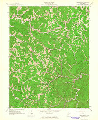 1962 Griffithsville1964 Print · USGSThe rural hollows of Lincoln and Boone counties are shown here in the early sixties during an era of intensive oil and gas development. Researchers can trace family history through dozens of named plots like Pauley Cem or locate community centers like Yawkey Sch and Morrisvale.3 unique versions available
End of results
Showing maps 1-2 of 2
Top cities near Yawkey
- Teays Valley historical maps
- South Charleston historical maps
- Saint Albans historical maps
- St. Albans historical maps
- Dunbar historical maps
- Hurricane historical maps
See more
Frequently asked questions
- What are the different types of historical maps available for Yawkey?
- What is the oldest map of Yawkey?
- Where can I purchase historical maps of Yawkey for my home or office?
- Where can I download high-res historical maps of Yawkey?
- Are there historical topographic maps available for Yawkey?
- Is there historical aerial imagery available for Yawkey?
- Where are historical maps of Yawkey sourced from?