1910s Maps of Man, West Virginia
Explore 2 historic maps of Man from the 1910s. These maps offer a rare glimpse into what life looked like during the 1910s — showing old roads, neighborhoods, homes, and landmarks that have changed or disappeared over time.
Whether you're researching your family's past, planning a metal detecting trip, or studying how Man's landscape evolved across the 1910s, these high-resolution maps are a powerful tool for exploring the history of this region.
- Focus on a specific era: All maps on this page are from the 1910s, giving you a focused view of this time period.
- See what’s changed: Compare century-old streets, trails, and buildings to today's modern landscape using overlays and satellite layers.
- Research with precision: Use these maps for genealogy, historical research, land use analysis, or educational projects.
- View, download, or print: Maps are fully viewable online in high resolution, and can be downloaded or printed for your own records.
Start exploring Man's history through authentic maps from the 1910s. This is your window into the past.
Man, WV maps
(2)- 1912 Map of Gilbert
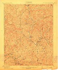 1912 Gilbert1912 Print · USGSThe Guyandot River valley and the industrial Tug Fork corridor define this region in the early nineteen-hundreds. Researchers can trace rail-tied settlements like Wharncliffe and War Eagle or find rural landmarks such as Twisted Gun Gap and North Spring.2 unique versions available
 - 1913 Map of Logan
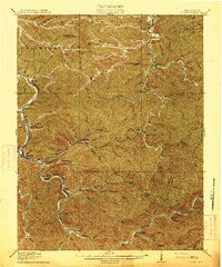 1913 Logan1913 Print · USGSThe West Virginia coalfields are seen here during their early industrial expansion in the years before the Great War. Genealogists and researchers can trace family landmarks and rail-side settlements like Logan, Pecks Mill, and Ethel along the Guyandot River.3 unique versions available
End of results
Showing maps 1-2 of 2
Top cities near Man
- Mallory historical maps
- Logan historical maps
- Oceana historical maps
- Chapmanville historical maps
- Holden historical maps
- Accoville historical maps
See more
Frequently asked questions
- What are the different types of historical maps available for Man?
- What is the oldest map of Man?
- Where can I purchase historical maps of Man for my home or office?
- Where can I download high-res historical maps of Man?
- Are there historical topographic maps available for Man?
- Is there historical aerial imagery available for Man?
- Where are historical maps of Man sourced from?