1990s Maps of Man, West Virginia
Explore 3 historic maps of Man from the 1990s. These maps offer a rare glimpse into what life looked like during the 1990s — showing old roads, neighborhoods, homes, and landmarks that have changed or disappeared over time.
Whether you're researching your family's past, planning a metal detecting trip, or studying how Man's landscape evolved across the 1990s, these high-resolution maps are a powerful tool for exploring the history of this region.
- Focus on a specific era: All maps on this page are from the 1990s, giving you a focused view of this time period.
- See what’s changed: Compare century-old streets, trails, and buildings to today's modern landscape using overlays and satellite layers.
- Research with precision: Use these maps for genealogy, historical research, land use analysis, or educational projects.
- View, download, or print: Maps are fully viewable online in high resolution, and can be downloaded or printed for your own records.
Start exploring Man's history through authentic maps from the 1990s. This is your window into the past.
Man, WV maps
(3)- 1996 Map of Amherstdale, 2002 Print
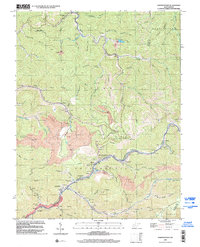 1996 Amherstdale2002 Print · USGSThe West Virginia coalfields are captured here in the mid-nineties, showing the intensive industrial landscape of the Buffalo Creek valley. Trace the legacy of mining towns like Amherstdale and Accoville alongside deep Mine works and the CSX rail lines.
 - 1996 Map of Mallory, 2003 Print
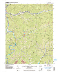 1996 Mallory2003 Print · USGSLogan County coal and gas country is captured here in the mid-1990s as the river valleys hummed with industrial activity. Genealogists and local historians can trace family sites like McDonald Cem, Emmanuel Ch, and the old post office at Greenville.
 - 1996 Map of Man, 2003 Print
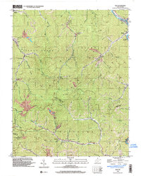 1996 Man2003 Print · USGSMid-century Logan and Mingo counties are defined here by a dense network of mining operations and river-valley settlements during the 1990s. Genealogists and historians can trace family locations through Greenville (Hunt PO), Stirrat, and Sarah Ann while locating historic coal infrastructure like Tipples and the Island Creek RR.
End of results
Showing maps 1-3 of 3
Top cities near Man
- Mallory historical maps
- Logan historical maps
- Oceana historical maps
- Chapmanville historical maps
- Holden historical maps
- Accoville historical maps
See more
Frequently asked questions
- What are the different types of historical maps available for Man?
- What is the oldest map of Man?
- Where can I purchase historical maps of Man for my home or office?
- Where can I download high-res historical maps of Man?
- Are there historical topographic maps available for Man?
- Is there historical aerial imagery available for Man?
- Where are historical maps of Man sourced from?