1900s (20th Century) Maps of Monitor, West Virginia
Explore 9 historic maps of Monitor from the 1900s (20th Century). These maps offer a rare glimpse into what life looked like during the 1900s — showing old roads, neighborhoods, homes, and landmarks that have changed or disappeared over time.
Whether you're researching your family's past, planning a metal detecting trip, or studying how Monitor's landscape evolved across the 1900s, these high-resolution maps are a powerful tool for exploring the history of this region.
- Focus on a specific era: All maps on this page are from the 1900s, giving you a focused view of this time period.
- See what’s changed: Compare century-old streets, trails, and buildings to today's modern landscape using overlays and satellite layers.
- Research with precision: Use these maps for genealogy, historical research, land use analysis, or educational projects.
- View, download, or print: Maps are fully viewable online in high resolution, and can be downloaded or printed for your own records.
Start exploring Monitor's history through authentic maps from the 1900s. This is your window into the past.
Monitor, WV maps
(9)- 1910 Map of Holden
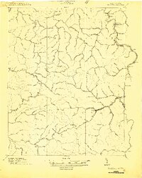 1910 Holden1910 Print · USGSLogan County’s rugged coalfield landscape is captured here in the early 1900s as development followed the winding Guyandot River. Researchers can trace old family-named settlements like Mc Cloud, Whirlwind, and Halcyon tucked into the hollows.
 - 1912 Map of Holden
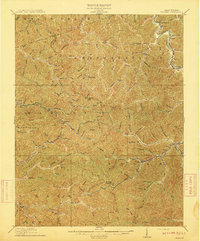 1912 Holden1912 Print · USGSSouthern West Virginia’s coal and rail landscape comes into focus at the dawn of the twentieth century. Genealogists and local historians can trace family-named hollows and early settlements like Holden, Whirlwind, and Chapmanville along the Guyandot River.
 - 1926 Map of Holden, 1957 Print
 1926 Holden1957 Print · USGSSouthern West Virginia in the mid-1920s shows a landscape of mountain schools and expanding rail networks. Researchers can trace dozens of early rural schools like Dave Dingess School and Hager School alongside rail hubs at Whitman Junction and Holden.
 - 1928 Map of Holden
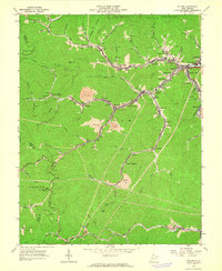
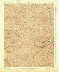 1928 Holden1928 Print · USGSLogan County's coal-country heart is captured here in the late twenties, showing the peak of the mountain rail and mining economy. Researchers can trace the narrow-gauge lines and spurs serving Holden, Verdunville, and Whitman Junction, while locating family landmarks like the Dave Dingess School or Ellis Camp.2 unique versions available
 - 1957 Map of Jenkins, 1974 Print
 1957 Jenkins1974 Print · USGSThe Cumberland Plateau in the mid-twentieth century reveals a complex landscape of winding river valleys and deep-seated industry. Genealogists and historians can trace the development of Hazard, Jenkins, and Pikeville alongside extensive Numerous Oil and Gas Fields and the routes of the Chesapeake & Ohio Railway.
 - 1960 Map of Jenkins
 1960 Jenkins1960 Print · USGSEastern Kentucky and the West Virginia borderlands are captured at a mid-century peak of the coal and rail era. Trace the industrial corridors of the Chesapeake and Ohio RR through mountain hubs like Hazard and Jenkins.
 - 1963 Map of Holden, 1964 Print
 1963 Holden1964 Print · USGSMid-century Logan County coal country is meticulously documented here as industry and community life centered on the narrow valleys. Genealogists and historians can locate family cemeteries such as Mounts Cemetery, local schools like Whitman School, and several churches including Number 21 Ch.3 unique versions available
 - 1982 Map of Williamson, 1983 Print
 1982 Williamson1983 Print · USGSThe Central Appalachian coalfields of West Virginia and Kentucky come into sharp focus here during the early eighties. Genealogists and researchers can trace the valley rail networks of the Norfolk and Western RR through Matewan, Williamson, and Blackberry City.
 - 1996 Map of Holden, 2002 Print
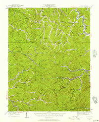
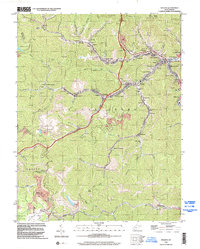 1996 Holden2002 Print · USGSLogan County coal country is detailed here in the late nineties, showing the dense network of mining towns and valley settlements. Genealogists can locate family landmarks like Farrar Cem and Whitman Cem, or local institutions like the Coal Miners Chapel.
End of results
Showing maps 1-9 of 9
Top cities near Monitor
- Madison historical maps
- Mallory historical maps
- Logan historical maps
- Chapmanville historical maps
- Holden historical maps
- Man historical maps
See more
Frequently asked questions
- What are the different types of historical maps available for Monitor?
- What is the oldest map of Monitor?
- Where can I purchase historical maps of Monitor for my home or office?
- Where can I download high-res historical maps of Monitor?
- Are there historical topographic maps available for Monitor?
- Is there historical aerial imagery available for Monitor?
- Where are historical maps of Monitor sourced from?