1920s Maps of Upper Whitman, West Virginia
Explore 2 historic maps of Upper Whitman from the 1920s. These maps offer a rare glimpse into what life looked like during the 1920s — showing old roads, neighborhoods, homes, and landmarks that have changed or disappeared over time.
Whether you're researching your family's past, planning a metal detecting trip, or studying how Upper Whitman's landscape evolved across the 1920s, these high-resolution maps are a powerful tool for exploring the history of this region.
- Focus on a specific era: All maps on this page are from the 1920s, giving you a focused view of this time period.
- See what’s changed: Compare century-old streets, trails, and buildings to today's modern landscape using overlays and satellite layers.
- Research with precision: Use these maps for genealogy, historical research, land use analysis, or educational projects.
- View, download, or print: Maps are fully viewable online in high resolution, and can be downloaded or printed for your own records.
Start exploring Upper Whitman's history through authentic maps from the 1920s. This is your window into the past.
Upper Whitman, WV maps
(2)- 1926 Map of Holden, 1957 Print
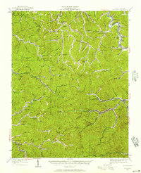 1926 Holden1957 Print · USGSSouthern West Virginia in the mid-1920s shows a landscape of mountain schools and expanding rail networks. Researchers can trace dozens of early rural schools like Dave Dingess School and Hager School alongside rail hubs at Whitman Junction and Holden.
 - 1928 Map of Holden
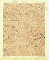 1928 Holden1928 Print · USGSLogan County's coal-country heart is captured here in the late twenties, showing the peak of the mountain rail and mining economy. Researchers can trace the narrow-gauge lines and spurs serving Holden, Verdunville, and Whitman Junction, while locating family landmarks like the Dave Dingess School or Ellis Camp.2 unique versions available
End of results
Showing maps 1-2 of 2
Top cities near Upper Whitman
- Williamson historical maps
- Mallory historical maps
- Logan historical maps
- Chapmanville historical maps
- Holden historical maps
- Man historical maps
See more
Frequently asked questions
- What are the different types of historical maps available for Upper Whitman?
- What is the oldest map of Upper Whitman?
- Where can I purchase historical maps of Upper Whitman for my home or office?
- Where can I download high-res historical maps of Upper Whitman?
- Are there historical topographic maps available for Upper Whitman?
- Is there historical aerial imagery available for Upper Whitman?
- Where are historical maps of Upper Whitman sourced from?