1990s Maps of Marshall County, West Virginia
Explore 6 historic maps of Marshall County from the 1990s. These maps offer a rare glimpse into what life looked like during the 1990s — showing old roads, neighborhoods, homes, and landmarks that have changed or disappeared over time.
Whether you're researching your family's past, planning a metal detecting trip, or studying how Marshall County's landscape evolved across the 1990s, these high-resolution maps are a powerful tool for exploring the history of this region.
- Focus on a specific era: All maps on this page are from the 1990s, giving you a focused view of this time period.
- See what’s changed: Compare century-old streets, trails, and buildings to today's modern landscape using overlays and satellite layers.
- Research with precision: Use these maps for genealogy, historical research, land use analysis, or educational projects.
- View, download, or print: Maps are fully viewable online in high resolution, and can be downloaded or printed for your own records.
Start exploring Marshall County's history through authentic maps from the 1990s. This is your window into the past.
Marshall County, WV maps
(6)- 1994 Map of Wheeling, 1998 Print
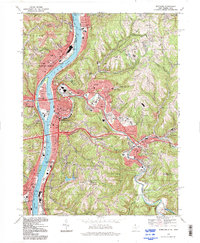 1994 Wheeling1998 Print · USGSThe Ohio River valley at the end of the twentieth century remains a dense corridor of industry and community spanning the state line. Researchers can trace historic neighborhoods from Warwood to Mozart or locate family sites at Greenwood Cemetery and Mt de Chantal Academy.
 - 1994 Map of New Martinsville, 1998 Print
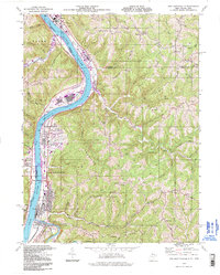 1994 New Martinsville1998 Print · USGSThe riverfront communities of Wetzel County were still thriving industrial centers when this mid-nineties survey was conducted. Local researchers can trace family landmarks and civic history through sites like the County Infirmary, Steelton Sch, and Palestine Ch.
 - 1997 Map of Moundsville, 1999 Print
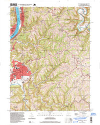 1997 Moundsville1999 Print · USGSThe Ohio River valley and its steep ridges are captured here during a period of late-twentieth-century industrial and correctional activity. Researchers can trace the massive State Penitentiary grounds, family cemeteries like Buchanan Cem, and rural centers such as Sherrard.
 - 1997 Map of Valley Grove, 2000 Print
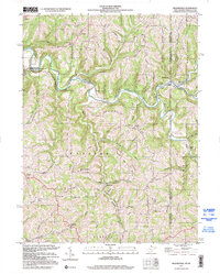
 1997 Valley Grove2000 Print · USGSThe West Virginia and Pennsylvania borderlands come alive in the late nineties, centered on the historic National Road corridor. Trace family roots at West Alexander and Triadelphia, or locate the old County Home and Sanatorium.
 - 1997 Map of Majorsville, 2000 Print
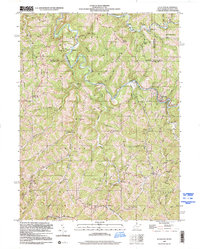
 1997 Majorsville2000 Print · USGSThe West Virginia and Pennsylvania borderlands come into focus in the late nineties, documenting the high ridges and deep hollows of Marshall County. Genealogists can trace family footprints through sites like Beelers Station Ch, Earlywine Cem, and the vanished site of Crows Mills.
 - 1998 Map of Littleton, 2000 Print
 1998 Littleton2000 Print · USGSThe West Virginia-Pennsylvania borderlands come into focus in the late nineties, showing a landscape of ridge-top farms and hollows. Genealogists and local historians can trace family roots at Jolliffee Cem, Miller Chapel, and the community of Littleton.
End of results
Showing maps 1-6 of 6
Top cities of Marshall County
- Moundsville historical maps
- McMechen historical maps
- Glen Dale historical maps
- Benwood historical maps
- Cameron historical maps
- Bartlett historical maps
Frequently asked questions
- What are the different types of historical maps available for Marshall County?
- What is the oldest map of Marshall County?
- Where can I purchase historical maps of Marshall County for my home or office?
- Where can I download high-res historical maps of Marshall County?
- Are there historical topographic maps available for Marshall County?
- Is there historical aerial imagery available for Marshall County?
- Where are historical maps of Marshall County sourced from?