1960s Maps of Marshall County, West Virginia
Explore 11 historic maps of Marshall County from the 1960s. These maps offer a rare glimpse into what life looked like during the 1960s — showing old roads, neighborhoods, homes, and landmarks that have changed or disappeared over time.
Whether you're researching your family's past, planning a metal detecting trip, or studying how Marshall County's landscape evolved across the 1960s, these high-resolution maps are a powerful tool for exploring the history of this region.
- Focus on a specific era: All maps on this page are from the 1960s, giving you a focused view of this time period.
- See what’s changed: Compare century-old streets, trails, and buildings to today's modern landscape using overlays and satellite layers.
- Research with precision: Use these maps for genealogy, historical research, land use analysis, or educational projects.
- View, download, or print: Maps are fully viewable online in high resolution, and can be downloaded or printed for your own records.
Start exploring Marshall County's history through authentic maps from the 1960s. This is your window into the past.
Marshall County, WV maps
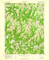
(11)- 1960 Map of Moundsville, 1961 Print
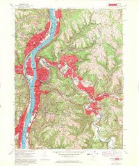
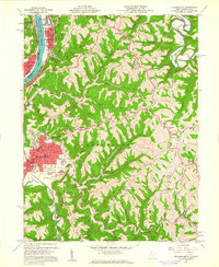 1960 Moundsville1961 Print · USGSMarshall County's riverfront industry and correctional history are on full display in this mid-century survey of the Ohio River valley. Genealogists and researchers can locate the State Penitentiary, trace rural churches on Waymans Ridge, and find local landmarks like the Grave Creek Indian Mound Museum.4 unique versions available
 - 1960 Map of Cameron, 1961 Print
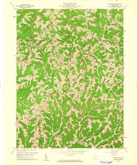
 1960 Cameron1961 Print · USGSThe Marshall County highlands are captured here in the early sixties, showing the vital link between the Baltimore and Ohio railroad and the town of Cameron. Researchers can trace old family names and rural sites like Mount Carmel Church, the Highland Cemetery, and the Gas Field near Kausooth.4 unique versions available
 - 1960 Map of Businessburg, 1961 Print
 1960 Businessburg1961 Print · USGSThe industrial and rural landscape along the Ohio River comes into focus in the early sixties. Genealogists can trace family names and local landmarks from Shadyside down to McKeefrey, including Mt Zion Cem and the Mead Local Sch.5 unique versions available
 - 1960 Map of Powhatan Point, 1961 Print
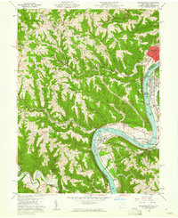
 1960 Powhatan Point1961 Print · USGSThe Ohio River valley at the start of the 1960s shows a landscape of industrial growth and rail transit. Trace the river-and-rail economy through Powhatan Point, Natrium, and the facilities at Lock No. 14.5 unique versions available
 - 1960 Map of Glen Easton, 1961 Print
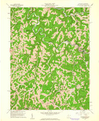
 1960 Glen Easton1961 Print · USGSMarshall County's ridgeline farms and narrow stream valleys are captured here at the start of the 1960s. Genealogists can trace family landmarks like Rosbys Rock, the Lower Bane Sch & Cem, and the winding Baltimore and Ohio Railroad.3 unique versions available
 - 1960 Map of Wileyville, 1962 Print
 1960 Wileyville1962 Print · USGSNorthern West Virginia hill country is shown here at the start of the sixties, defined by its steep ridge-and-hollow topography. Genealogists can trace family roots through remote landmarks like Saint Joseph Ch, Grandview Sch, and the Wileyville Cem.2 unique versions available
 - 1960 Map of Littleton, 1962 Print
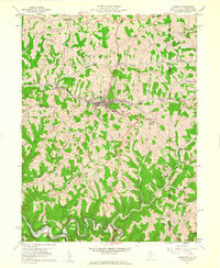
 1960 Littleton1962 Print · USGSWetzel County in the early sixties was a landscape of winding creek valleys and oil-and-gas development. Trace the Baltimore and Ohio RR through Littleton and locate remote landmarks like Miller Chapel and Mount Zion Cem.2 unique versions available
 - 1960 Map of New Martinsville, 1962 Print
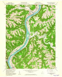
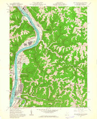 1960 New Martinsville1962 Print · USGSThe industrial and river life of the Ohio Valley is captured here at the start of the 1960s, centered on the growing hub of New Martinsville. Genealogists and historians can trace the B & O rail lines, old schools like Steelton Sch, and numerous family-named landmarks from Wells Bottom to Schupbach Ridge.4 unique versions available
 - 1961 Map of Clarksburg
 1961 Clarksburg1961 Print · USGSThe mid-century industrial and river landscapes of West Virginia and Ohio are detailed here, centered on the Ohio River. Researchers can trace the Baltimore and Ohio rail lines connecting towns like Parkersburg, Clarksburg, and Monongah.
 - 1962 Map of Canton
 1962 Canton1962 Print · USGSThe industrial heartland of Eastern Ohio and Western Pennsylvania thrives in the early sixties as steel mills and rail lines dominate the river valleys. Genealogists and historians can trace local landmarks like McKinley National Memorial, Malone College, and industrial sites such as Republic Steel Corp.2 unique versions available
 - 1968 Map of Wheeling, 1971 Print
 1968 Wheeling1971 Print · USGSThe Ohio River valley thrives during the late sixties as a center of industry and education spanning the West Virginia and Ohio border. Local historians can trace established neighborhoods and institutions like Wheeling Island, Mt de Chantal Academy, and the grounds of Oglebay Park.4 unique versions available
End of results
Showing maps 1-11 of 11
Top cities of Marshall County
- Moundsville historical maps
- McMechen historical maps
- Glen Dale historical maps
- Benwood historical maps
- Cameron historical maps
- Bartlett historical maps
Frequently asked questions
- What are the different types of historical maps available for Marshall County?
- What is the oldest map of Marshall County?
- Where can I purchase historical maps of Marshall County for my home or office?
- Where can I download high-res historical maps of Marshall County?
- Are there historical topographic maps available for Marshall County?
- Is there historical aerial imagery available for Marshall County?
- Where are historical maps of Marshall County sourced from?