1960s Maps of Woodruff, West Virginia
Explore 2 historic maps of Woodruff from the 1960s. These maps offer a rare glimpse into what life looked like during the 1960s — showing old roads, neighborhoods, homes, and landmarks that have changed or disappeared over time.
Whether you're researching your family's past, planning a metal detecting trip, or studying how Woodruff's landscape evolved across the 1960s, these high-resolution maps are a powerful tool for exploring the history of this region.
- Focus on a specific era: All maps on this page are from the 1960s, giving you a focused view of this time period.
- See what’s changed: Compare century-old streets, trails, and buildings to today's modern landscape using overlays and satellite layers.
- Research with precision: Use these maps for genealogy, historical research, land use analysis, or educational projects.
- View, download, or print: Maps are fully viewable online in high resolution, and can be downloaded or printed for your own records.
Start exploring Woodruff's history through authentic maps from the 1960s. This is your window into the past.
Woodruff, WV maps
(2)- 1960 Map of Cameron, 1961 Print
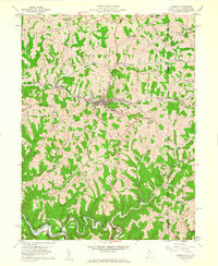 1960 Cameron1961 Print · USGSThe Marshall County highlands are captured here in the early sixties, showing the vital link between the Baltimore and Ohio railroad and the town of Cameron. Researchers can trace old family names and rural sites like Mount Carmel Church, the Highland Cemetery, and the Gas Field near Kausooth.4 unique versions available
 - 1961 Map of Clarksburg
 1961 Clarksburg1961 Print · USGSThe mid-century industrial and river landscapes of West Virginia and Ohio are detailed here, centered on the Ohio River. Researchers can trace the Baltimore and Ohio rail lines connecting towns like Parkersburg, Clarksburg, and Monongah.
End of results
Showing maps 1-2 of 2
Top cities near Woodruff
- Moundsville historical maps
- Bellaire historical maps
- Shadyside historical maps
- McMechen historical maps
- East Finley Township historical maps
- Glen Dale historical maps
See more
Frequently asked questions
- What are the different types of historical maps available for Woodruff?
- What is the oldest map of Woodruff?
- Where can I purchase historical maps of Woodruff for my home or office?
- Where can I download high-res historical maps of Woodruff?
- Are there historical topographic maps available for Woodruff?
- Is there historical aerial imagery available for Woodruff?
- Where are historical maps of Woodruff sourced from?