1920s Maps of Hartmansville, West Virginia
Explore 2 historic maps of Hartmansville from the 1920s. These maps offer a rare glimpse into what life looked like during the 1920s — showing old roads, neighborhoods, homes, and landmarks that have changed or disappeared over time.
Whether you're researching your family's past, planning a metal detecting trip, or studying how Hartmansville's landscape evolved across the 1920s, these high-resolution maps are a powerful tool for exploring the history of this region.
- Focus on a specific era: All maps on this page are from the 1920s, giving you a focused view of this time period.
- See what’s changed: Compare century-old streets, trails, and buildings to today's modern landscape using overlays and satellite layers.
- Research with precision: Use these maps for genealogy, historical research, land use analysis, or educational projects.
- View, download, or print: Maps are fully viewable online in high resolution, and can be downloaded or printed for your own records.
Start exploring Hartmansville's history through authentic maps from the 1920s. This is your window into the past.
Hartmansville, WV maps
(2)- 1920 Map of Elk Garden
 1920 Elk Garden1920 Print · USGSThe West Virginia highlands and the Potomac River border are captured here just after the Great War, during the peak of the rail-and-coal era. Genealogists can locate numerous rural landmarks including Elk Garden, Rehoboth Church, and the Nethken School.
 - 1922 Map of Elk Garden
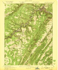 1922 Elk Garden1922 Print · USGSThe Potomac River highlands come to life in the early 1920s as rail and river industry define the border between Maryland and West Virginia. Genealogists and local historians can trace family roots through numerous small schools and churches like Sunnyside School, Mt Pisgah Church, and Hartmansville.2 unique versions available
End of results
Showing maps 1-2 of 2
Top cities near Hartmansville
- Keyser historical maps
- Mountain Lake Park historical maps
- Westernport historical maps
- Oakland historical maps
- Piedmont historical maps
- Loch Lynn Heights historical maps
See more
Frequently asked questions
- What are the different types of historical maps available for Hartmansville?
- What is the oldest map of Hartmansville?
- Where can I purchase historical maps of Hartmansville for my home or office?
- Where can I download high-res historical maps of Hartmansville?
- Are there historical topographic maps available for Hartmansville?
- Is there historical aerial imagery available for Hartmansville?
- Where are historical maps of Hartmansville sourced from?