1910s Maps of Williamson Terrace, Williamson
Explore 2 historic maps of Williamson Terrace from the 1910s. These maps offer a rare glimpse into what life looked like during the 1910s — showing old roads, neighborhoods, homes, and landmarks that have changed or disappeared over time.
Whether you're researching your family's past, planning a metal detecting trip, or studying how Williamson Terrace's landscape evolved across the 1910s, these high-resolution maps are a powerful tool for exploring the history of this region.
- Focus on a specific era: All maps on this page are from the 1910s, giving you a focused view of this time period.
- See what’s changed: Compare century-old streets, trails, and buildings to today's modern landscape using overlays and satellite layers.
- Research with precision: Use these maps for genealogy, historical research, land use analysis, or educational projects.
- View, download, or print: Maps are fully viewable online in high resolution, and can be downloaded or printed for your own records.
Start exploring Williamson Terrace's history through authentic maps from the 1910s. This is your window into the past.
Williamson Terrace, Williamson maps
(2)- 1915 Map of Williamson
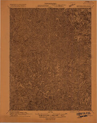 1915 Williamson1915 Print · USGSThe borderlands of the Tug Fork river come alive in this early century survey of the Central Appalachian coal country. Genealogists and local historians can trace the early rail-side growth of Williamson, Chattaroy, and Nolan along the Norfolk and Western Ry.2 unique versions available
 - 1918 Map of Williamson
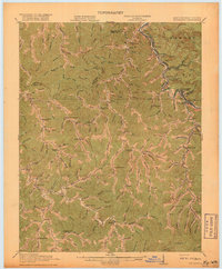 1918 Williamson1918 Print · USGSThe Tug Fork river valley at the Kentucky-West Virginia border comes alive in this survey from the era of the Great War. Researchers can trace the path of the Norfolk and Western RR through Williamson or locate rural schools like Hammon Manor School and the Pinson Fork P O Peg Sta.3 unique versions available
End of results
Showing maps 1-2 of 2
Frequently asked questions
- What are the different types of historical maps available for Williamson Terrace?
- What is the oldest map of Williamson Terrace?
- Where can I purchase historical maps of Williamson Terrace for my home or office?
- Where can I download high-res historical maps of Williamson Terrace?
- Are there historical topographic maps available for Williamson Terrace?
- Is there historical aerial imagery available for Williamson Terrace?
- Where are historical maps of Williamson Terrace sourced from?