1920s Maps of Centennial, West Virginia
Explore 2 historic maps of Centennial from the 1920s. These maps offer a rare glimpse into what life looked like during the 1920s — showing old roads, neighborhoods, homes, and landmarks that have changed or disappeared over time.
Whether you're researching your family's past, planning a metal detecting trip, or studying how Centennial's landscape evolved across the 1920s, these high-resolution maps are a powerful tool for exploring the history of this region.
- Focus on a specific era: All maps on this page are from the 1920s, giving you a focused view of this time period.
- See what’s changed: Compare century-old streets, trails, and buildings to today's modern landscape using overlays and satellite layers.
- Research with precision: Use these maps for genealogy, historical research, land use analysis, or educational projects.
- View, download, or print: Maps are fully viewable online in high resolution, and can be downloaded or printed for your own records.
Start exploring Centennial's history through authentic maps from the 1920s. This is your window into the past.
Centennial, WV maps
(2)- 1921 Map of Ronceverte
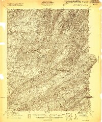 1921 Ronceverte1921 Print · USGSThe West Virginia and Virginia borderlands come alive in this early 1920s record of the Greenbrier Valley and Allegheny ridges. Genealogists can trace family roots through numerous local landmarks like Organ Cave, Red Mill, and the Highland Green School.2 unique versions available
 - 1923 Map of Ronceverte
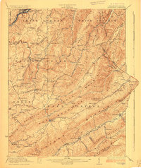 1923 Ronceverte1923 Print · USGSSoutheast West Virginia in the early twenties is a landscape of mountain ridges and remote hollows. Genealogists can trace the rural communities of Gap Mills and Sweet Springs, alongside dozens of landmarks like Organ Cave and Schley School.4 unique versions available
End of results
Showing maps 1-2 of 2
Top cities near Centennial
- Lewisburg historical maps
- White Sulphur Springs historical maps
- Fairlea historical maps
- Ronceverte historical maps
- Union historical maps
- New Castle historical maps
Frequently asked questions
- What are the different types of historical maps available for Centennial?
- What is the oldest map of Centennial?
- Where can I purchase historical maps of Centennial for my home or office?
- Where can I download high-res historical maps of Centennial?
- Are there historical topographic maps available for Centennial?
- Is there historical aerial imagery available for Centennial?
- Where are historical maps of Centennial sourced from?