1920s Maps of Marlinton, West Virginia
Explore 4 historic maps of Marlinton from the 1920s. These maps offer a rare glimpse into what life looked like during the 1920s — showing old roads, neighborhoods, homes, and landmarks that have changed or disappeared over time.
Whether you're researching your family's past, planning a metal detecting trip, or studying how Marlinton's landscape evolved across the 1920s, these high-resolution maps are a powerful tool for exploring the history of this region.
- Focus on a specific era: All maps on this page are from the 1920s, giving you a focused view of this time period.
- See what’s changed: Compare century-old streets, trails, and buildings to today's modern landscape using overlays and satellite layers.
- Research with precision: Use these maps for genealogy, historical research, land use analysis, or educational projects.
- View, download, or print: Maps are fully viewable online in high resolution, and can be downloaded or printed for your own records.
Start exploring Marlinton's history through authentic maps from the 1920s. This is your window into the past.
Marlinton, WV maps
(4)- 1923 Map of Marlinton
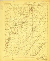 1923 Marlinton1923 Print · USGSPocahontas County at the start of the twenties shows a landscape defined by the timber industry and the winding Greenbrier River. Genealogists can trace family names through dozens of rural landmarks, including Grimes School, Hefners School, and May Chapel.6 unique versions available
 - 1923 Map of Mingo
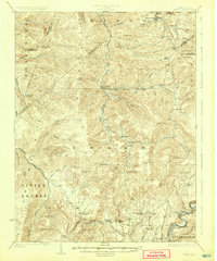
 1923 Mingo1923 Print · USGSThe West Virginia highlands are shown in detail during the early twenties, highlighting the region's timber-driven economy and remote mountain enclaves. Genealogists can locate family-named schools and churches like Hannah School, Marys Chapel, and West Union Church along the winding Lumber RR.2 unique versions available
 - 1925 Map of Mingo
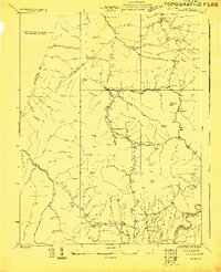
 1925 Mingo1925 Print · USGSPocahontas County at the headwaters of the Greenbrier is seen here in the mid-twenties, a landscape of high ridges and isolated mountain valleys. Researchers can locate dozens of early rural schools like Yewglade School and churches such as Marys Chapel or Poage Chapel.4 unique versions available
 - 1925 Map of Marlinton
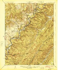 1925 Marlinton1925 Print · USGSMarlinton and the Greenbrier River valley are captured in the mid-twenties, showing a landscape defined by the Chesapeake and Ohio railroad. Genealogy researchers can locate family landmarks like Locust PO, Trinity Church, and many rural schools.3 unique versions available
End of results
Showing maps 1-4 of 4
Top cities near Marlinton
Top neighborhoods of Marlinton
Frequently asked questions
- What are the different types of historical maps available for Marlinton?
- What is the oldest map of Marlinton?
- Where can I purchase historical maps of Marlinton for my home or office?
- Where can I download high-res historical maps of Marlinton?
- Are there historical topographic maps available for Marlinton?
- Is there historical aerial imagery available for Marlinton?
- Where are historical maps of Marlinton sourced from?