1990s Maps of Marlinton, West Virginia
Explore 3 historic maps of Marlinton from the 1990s. These maps offer a rare glimpse into what life looked like during the 1990s — showing old roads, neighborhoods, homes, and landmarks that have changed or disappeared over time.
Whether you're researching your family's past, planning a metal detecting trip, or studying how Marlinton's landscape evolved across the 1990s, these high-resolution maps are a powerful tool for exploring the history of this region.
- Focus on a specific era: All maps on this page are from the 1990s, giving you a focused view of this time period.
- See what’s changed: Compare century-old streets, trails, and buildings to today's modern landscape using overlays and satellite layers.
- Research with precision: Use these maps for genealogy, historical research, land use analysis, or educational projects.
- View, download, or print: Maps are fully viewable online in high resolution, and can be downloaded or printed for your own records.
Start exploring Marlinton's history through authentic maps from the 1990s. This is your window into the past.
Marlinton, WV maps
(3)- 1995 Map of Edray, 1998 Print
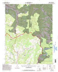 1995 Edray1998 Print · USGSPocahontas County is shown during the mid-1990s, revealing a landscape of forested ridges and river valleys east of the Greenbrier River. Researchers can locate historic rural centers like Edray and Brownsburg or trace family sites such as Gibson Cem and Woods-Poage Chapel.
 - 1995 Map of Marlinton, 1998 Print
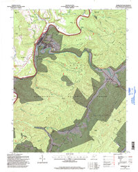 1995 Marlinton1998 Print · USGSMarlinton and the surrounding Pocahontas County highlands are captured here in the mid-1990s as the Greenbrier River winds through the National Forest. Researchers can locate family sites at Mountain View Cem, the remote Cummings Creek Ch, or the historic crossroads of Huntersville.
 - 1995 Map of Hillsboro, 1998 Print
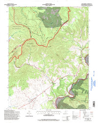 1995 Hillsboro1998 Print · USGSPocahontas County in the 1990s shows a mix of pastoral river valley life and high-altitude wilderness. Genealogists and historians can locate family landmarks like the Pearl S Buck Birthplace and Marvin Chapel, or trace the old roads through Hillsboro and Mill Point.
End of results
Showing maps 1-3 of 3
Top cities near Marlinton
Top neighborhoods of Marlinton
Frequently asked questions
- What are the different types of historical maps available for Marlinton?
- What is the oldest map of Marlinton?
- Where can I purchase historical maps of Marlinton for my home or office?
- Where can I download high-res historical maps of Marlinton?
- Are there historical topographic maps available for Marlinton?
- Is there historical aerial imagery available for Marlinton?
- Where are historical maps of Marlinton sourced from?