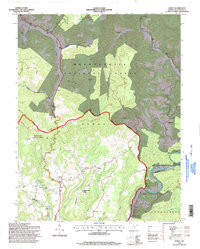
1995 Map of Edray
USGS Topo · Published 1998About this map
The Greenbrier River carves a winding path through this portion of Pocahontas County, defining the eastern boundary of a landscape shaped by narrow valleys and high ridges. The settlement of Edray serves as a central hub, surrounded by smaller communities such as Onoto and Brownsburg. This 1990s revision reveals a territory deeply integrated with the Monongahela National Forest, where the Highland Scenic Highway traverses high elevations like Elk Mtn and Gay Knob. Local life is anchored by numerous rural landmarks, including Wilson Chapel and Hamlin Chapel, alongside essential infrastructure like the Fish Hatchery and Gaging Sta. The inclusion of family-named sites like Gibson Cem and Hannah Cem provides vital points of reference for genealogists tracing ancestral homesteads near Stoney Creek and Thorny Creek.
Find a feature on this map
48 named features on this map. Tap any name to fly to it.
Don’t see what you’re looking for? This feature index may not catch every label — zoom into the map to look around manually.
Map Details
Editions of this 1995 Edray Map
This is the sole edition of this map. No revisions or reprints were ever made.
Other maps of this area

1891 · Huntersville
USGS Topo · 1:125,000

1894 · Huntersville
USGS Topo · 1:125,000

1901 · Monterey
USGS Topo · 1:125,000

1922 · Cass
USGS Topo · 1:48,000

1923 · Marlinton
USGS Topo · 1:48,000

1923 · Warm Springs
USGS Topo · 1:48,000

1923 · Mingo
USGS Topo · 1:48,000

1924 · Cass
USGS Topo · 1:62,500

1925 · Mingo
USGS Topo · 1:62,500

1925 · Marlinton
USGS Topo · 1:62,500