
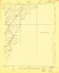
1923 Map of Warm Springs
USGS Topo · Published 1923About this map
Minnehaha Springs sits at a crossroads of mountain terrain and early rural infrastructure in this 1923 survey. The landscape is defined by the sharp transition between West Virginia and Virginia, specifically where Pocahontas Co and Greenbrier Co meet the Virginia line. This era shows a high density of small-scale educational and spiritual centers, such as the Mt Tabor School, Moore School, and the Westminster Church, which served the scattered residents living along the hollows and runs.
Find a feature on this map
33 named features on this map. Tap any name to fly to it.
Don’t see what you’re looking for? This feature index may not catch every label — zoom into the map to look around manually.
Map Details
Editions of this 1923 Warm Springs Map
2 editions found
Other maps of this area

1887 · Lewisburg
USGS Topo · 1:125,000

1891 · Lewisburg
USGS Topo · 1:125,000

1891 · Huntersville
USGS Topo · 1:125,000

1894 · Huntersville
USGS Topo · 1:125,000

1894 · Natural Bridge
USGS Topo · 1:125,000

1901 · Monterey
USGS Topo · 1:125,000

1921 · Callaghan
USGS Topo · 1:48,000

1922 · Cass
USGS Topo · 1:48,000

1923 · Marlinton
USGS Topo · 1:48,000

1923 · Callaghan
USGS Topo · 1:62,500