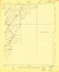
1923 Map of Warm Springs
USGS Topo · Published 1923About this map
Allegheny Mountain defines the jagged interstate boundary between West Virginia and Virginia in this 1923 survey. The landscape is characterized by a series of parallel ridges and hollows, including Lockridge Mountain and Marlin Mtn, where small rural communities are connected by the Huntersville Road and Timber Rd. Along the winding course of Knapp Creek, the settlement of Minnehaha Springs serves as a local focal point, while further south, the Rimel area shows a concentration of civic life with the Rimel School and nearby Riders Gap.
Find a feature on this map
67 named features on this map. Tap any name to fly to it.
Don’t see what you’re looking for? This feature index may not catch every label — zoom into the map to look around manually.
Map Details
Editions of this 1923 Warm Springs Map
2 editions found
Other maps of this area

1887 · Lewisburg
USGS Topo · 1:125,000

1891 · Lewisburg
USGS Topo · 1:125,000

1891 · Huntersville
USGS Topo · 1:125,000

1894 · Huntersville
USGS Topo · 1:125,000

1894 · Natural Bridge
USGS Topo · 1:125,000

1901 · Monterey
USGS Topo · 1:125,000

1921 · Callaghan
USGS Topo · 1:48,000

1922 · Cass
USGS Topo · 1:48,000

1923 · Marlinton
USGS Topo · 1:48,000

1923 · Warm Springs
USGS Topo · 1:48,000