Old Maps of Rimel, West Virginia for Metal Detecting
Plan your next treasure hunt with 17 historic maps of Rimel. Find old homesites, ghost towns, trails, and gathering spots that may be lost to time — perfect for identifying promising metal detecting locations.
- Locate forgotten sites: Uncover places like long-lost settlements, abandoned rail lines, or gathering spots.
- Plan better hunts: Use map overlays combined with LiDAR or satellite views to narrow in on historically rich areas.
- Made for detectorists: Thousands of hobbyists use these maps to discover relics, coins, and hidden history.
Use these historic maps to boost your research and find new opportunities beneath the surface of Rimel.
Rimel, WV maps
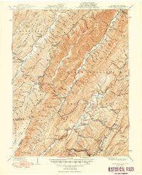
(17)- 1901 Map of Monterey, 1905 Print
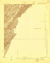
 1901 Monterey1905 Print · USGSThe high Allegheny ridges of Highland and Bath Counties are shown at the turn of the century when isolated valley settlements were linked by winding mountain gaps. Genealogists can trace early homesteads and commerce centers like Cleeks Mills, Mountaingrove, and New Hampden.8 unique versions available
 - 1923 Map of Warm Springs
 1923 Warm Springs1923 Print · USGSThe mountain border between West Virginia and Virginia comes into focus in the early 1920s, revealing a landscape of remote mountain gaps and hollows. Researchers can locate numerous local landmarks like Minnehaha Springs, Mt Carmel Church, and the Circle Hill School.2 unique versions available
 - 1926 Map of Warm Springs
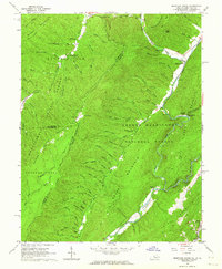
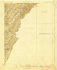 1926 Warm Springs1926 Print · USGSThe West Virginia and Virginia borderlands come alive in this mid-1920s survey of the high Alleghenies. Researchers can trace rural life through landmarks like Minnehaha Springs, Westminster Church, and schools at Rimel and Sunset.5 unique versions available
 - 1930 Map of Mountain Grove
 1930 Mountain Grove1930 Print · USGSThe Virginia and West Virginia borderlands in the late 1920s are captured here during a time of isolated mountain settlements and river-bottom farming. Genealogists can trace family footprints through the numerous named hollows and crossings like Mcclintic Bridge, Mountain Grove, and Mooretown.
 - 1933 Map of Mountain Grove
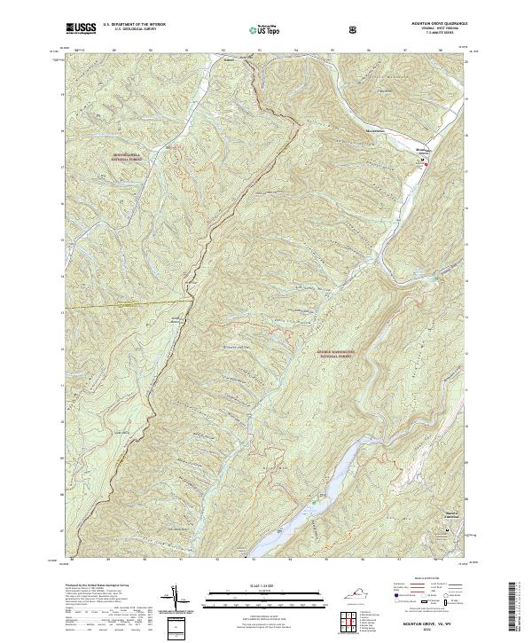
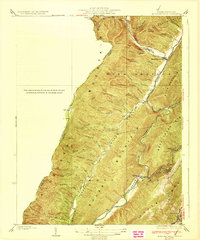 1933 Mountain Grove1933 Print · USGSBath County's high ridges and river valleys are captured here in the early 1930s as a network of mountain hollows and small settlements. Genealogists and local historians can locate Mooretown, trace the namesake Mountain Grove, and find the Mailbox Sch and Eden Ch.3 unique versions available
 - 1946 Map of Warm Springs, 1962 Print
 1946 Warm Springs1962 Print · USGSBath County and the Allegheny borderlands are captured here in the mid-1940s, showing the early infrastructure of this resort and timber region. Researchers can trace family sites at Mountain Grove, rural pulpits like Mt Hope Ch, and the crossing at Moclintic Bridge.2 unique versions available
 - 1949 Map of Charlottesville
 1949 Charlottesville1949 Print · USGSThe Shenandoah Valley and Blue Ridge appear in the late 1940s as a thriving corridor of rail and river commerce. Researchers can trace the mid-century footprints of Harrisonburg, Staunton, and Culpeper alongside the historic routes of the Southern Railway.2 unique versions available
 - 1949 Map of Warm Springs
 1949 Warm Springs1949 Print · USGSThe Virginia and West Virginia borderlands are documented here in the late 1940s, highlighting the famous resort springs and rugged Appalachian ridges. Genealogists can trace family locations near Warm Springs, Bacova, and the Chimney Run Ch or Zion Hill Ch.2 unique versions available
 - 1956 Map of Charlottesville, 1966 Print
 1956 Charlottesville1966 Print · USGSThe Shenandoah Valley and Blue Ridge are captured in detail during the mid-1960s as the modern interstate system began to emerge. Genealogists and historians can trace rail-connected hubs like Waynesboro or follow the river paths of the Rapidan River and Rivanna River.4 unique versions available
 - 1961 Map of Mountain Grove, 1964 Print
 1961 Mountain Grove1964 Print · USGSThe Virginia and West Virginia borderlands in the early 1960s feature a network of high ridges and isolated hollows. Genealogists and historians can trace family-named sites like Mooretown and Gochran Creek Ch, or locate the Chesapeake and Ohio line near Bacova Junction.2 unique versions available
 - 1986 Map of Staunton
 1986 Staunton1986 Print · USGSThe Shenandoah Valley and Allegheny Highlands meet in the mid-1980s, revealing a landscape of historic mountain towns and thermal resorts. Genealogists and historians can trace institutional landmarks like Mary Baldwin College or follow the legacy of the Chesapeake and Ohio Railroad through Craigsville and Swoope.2 unique versions available
 - 1995 Map of Mountain Grove, 1998 Print
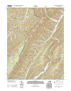
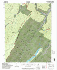 1995 Mountain Grove1998 Print · USGSThe Virginia and West Virginia borderlands are shown in the 1990s as a landscape of forest management and early recreation. Researchers can trace family-named hollows and historic rural sites like Cochran Creek Ch and the northern tip of Lake Moomaw.
 - 2011 Map of Mountain Grove, 2011 Print
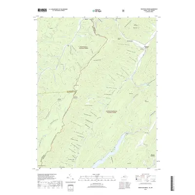
 2011 Mountain Grove2011 Print · USGSCovers Rimel, including Mooretown, Mountain Grove, and other nearby areas
 - 2013 Map of Mountain Grove, 2013 Print
 2013 Mountain Grove2013 Print · USGSCovers Rimel, including Mooretown, Mountain Grove, and other nearby areas
 - 2016 Map of Mountain Grove, 2016 Print
 2016 Mountain Grove2016 Print · USGSCovers Rimel, including Mooretown, Mountain Grove, and other nearby areas
 - 2019 Map of Mountain Grove, 2019 Print
 2019 Mountain Grove2019 Print · USGSCovers Rimel, including Mooretown, Mountain Grove, and other nearby areas
 - 2022 Map of Mountain Grove, 2022 Print
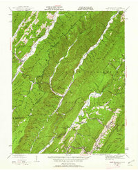
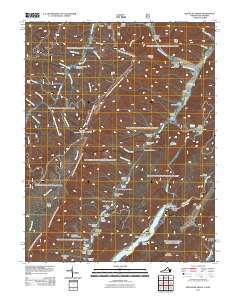
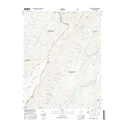
 2022 Mountain Grove2022 Print · USGSHigh in the Allegheny Mountains along the Virginia and West Virginia border, this modern survey details a landscape of deep hollows and forest ridges. Genealogists can trace family landmarks like the McClintic Family Cem or find Rimel and the Eden United Methodist Church near the Jackson River.
End of results
Showing maps 1-17 of 17
Top cities near Rimel
Frequently asked questions
- What are the different types of historical maps available for Rimel?
- What is the oldest map of Rimel?
- Where can I purchase historical maps of Rimel for my home or office?
- Where can I download high-res historical maps of Rimel?
- Are there historical topographic maps available for Rimel?
- Is there historical aerial imagery available for Rimel?
- Where are historical maps of Rimel sourced from?