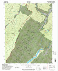
1995 Map of Mountain Grove
USGS Topo · Published 1998About this map
Mountain Grove serves as the primary settlement hub in this 1990s-era map of the Virginia and West Virginia borderlands. The landscape is defined by the significant presence of public lands, including the George Washington National Forest and the T M Gathright Wildlife Management Area. The southern portion of the map is dominated by the northern reaches of Lake Moomaw, which creates a jagged shoreline along the slopes of Bolar Mountain.
Find a feature on this map
83 named features on this map. Tap any name to fly to it.
Don’t see what you’re looking for? This feature index may not catch every label — zoom into the map to look around manually.
Map Details
Editions of this 1995 Mountain Grove Map
This is the sole edition of this map. No revisions or reprints were ever made.
Other maps of this area

1887 · Lewisburg
USGS Topo · 1:125,000

1891 · Lewisburg
USGS Topo · 1:125,000

1891 · Huntersville
USGS Topo · 1:125,000

1894 · Huntersville
USGS Topo · 1:125,000

1894 · Natural Bridge
USGS Topo · 1:125,000

1901 · Monterey
USGS Topo · 1:125,000

1921 · Callaghan
USGS Topo · 1:48,000

1923 · Marlinton
USGS Topo · 1:48,000

1923 · Warm Springs
USGS Topo · 1:48,000

1923 · Callaghan
USGS Topo · 1:62,500