1920s Maps of Tunnelton, West Virginia
Explore 2 historic maps of Tunnelton from the 1920s. These maps offer a rare glimpse into what life looked like during the 1920s — showing old roads, neighborhoods, homes, and landmarks that have changed or disappeared over time.
Whether you're researching your family's past, planning a metal detecting trip, or studying how Tunnelton's landscape evolved across the 1920s, these high-resolution maps are a powerful tool for exploring the history of this region.
- Focus on a specific era: All maps on this page are from the 1920s, giving you a focused view of this time period.
- See what’s changed: Compare century-old streets, trails, and buildings to today's modern landscape using overlays and satellite layers.
- Research with precision: Use these maps for genealogy, historical research, land use analysis, or educational projects.
- View, download, or print: Maps are fully viewable online in high resolution, and can be downloaded or printed for your own records.
Start exploring Tunnelton's history through authentic maps from the 1920s. This is your window into the past.
Tunnelton, WV maps
(2)- 1925 Map of Kingwood
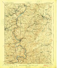 1925 Kingwood1925 Print · USGSPreston County in the mid-twenties shows a landscape shaped by the Baltimore and Ohio Railroad and the winding Cheat River. Genealogists can locate dozens of country schools and churches, from St Josephs Church to the Washington Manor School and the Pleasant Valley Ford.3 unique versions available
 - 1926 Map of Thornton
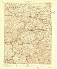 1926 Thornton1926 Print · USGSPreston and Taylor counties show a dense network of mountain settlements and rail corridors in the mid-1920s. Genealogists can locate family landmarks such as Slabcamp Church, the Pell School, and rail-side towns like Tunnelton or Newburg.2 unique versions available
End of results
Showing maps 1-2 of 2
Top cities near Tunnelton
- Morgantown historical maps
- Westover historical maps
- Kingwood historical maps
- Terra Alta historical maps
- Masontown historical maps
- Rowlesburg historical maps
See more
Frequently asked questions
- What are the different types of historical maps available for Tunnelton?
- What is the oldest map of Tunnelton?
- Where can I purchase historical maps of Tunnelton for my home or office?
- Where can I download high-res historical maps of Tunnelton?
- Are there historical topographic maps available for Tunnelton?
- Is there historical aerial imagery available for Tunnelton?
- Where are historical maps of Tunnelton sourced from?