1900-1909 Maps of Winfield Way, Winfield
Explore 2 historic maps of Winfield Way from 1900-1909. These maps offer a rare glimpse into what life looked like during the 1900s — showing old roads, neighborhoods, homes, and landmarks that have changed or disappeared over time.
Whether you're researching your family's past, planning a metal detecting trip, or studying how Winfield Way's landscape evolved across the 1900s, these high-resolution maps are a powerful tool for exploring the history of this region.
- Focus on a specific era: All maps on this page are from the 1900s, giving you a focused view of this time period.
- See what’s changed: Compare century-old streets, trails, and buildings to today's modern landscape using overlays and satellite layers.
- Research with precision: Use these maps for genealogy, historical research, land use analysis, or educational projects.
- View, download, or print: Maps are fully viewable online in high resolution, and can be downloaded or printed for your own records.
Start exploring Winfield Way's history through authentic maps from the 1900s. This is your window into the past.
Winfield Way, Winfield maps
(2)- 1906 Map of Winfield, 1961 Print
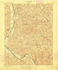
 1906 Winfield1961 Print · USGSThe Kanawha River valley at the turn of the century shows a landscape defined by river locks and the growing influence of the railroad. Genealogists and historians can trace old homesteads and landings from Redhouse Shoals to the small village of Confidence.
 - 1908 Map of Winfield
 1908 Winfield1908 Print · USGSThe Kanawha River valley at the turn of the century shows a landscape defined by river traffic and rail expansion. Genealogists and historians can trace riverside settlements like Winfield and Buffalo, or find lost rail stops and river locks including Lock No 10 and Black Betsey.3 unique versions available
End of results
Showing maps 1-2 of 2
Top cities near Winfield Way
- Charleston historical maps
- Teays Valley historical maps
- South Charleston historical maps
- Saint Albans historical maps
- St. Albans historical maps
- Dunbar historical maps
See more
Frequently asked questions
- What are the different types of historical maps available for Winfield Way?
- What is the oldest map of Winfield Way?
- Where can I purchase historical maps of Winfield Way for my home or office?
- Where can I download high-res historical maps of Winfield Way?
- Are there historical topographic maps available for Winfield Way?
- Is there historical aerial imagery available for Winfield Way?
- Where are historical maps of Winfield Way sourced from?