1990s Maps of Raleigh County, West Virginia
Explore 8 historic maps of Raleigh County from the 1990s. These maps offer a rare glimpse into what life looked like during the 1990s — showing old roads, neighborhoods, homes, and landmarks that have changed or disappeared over time.
Whether you're researching your family's past, planning a metal detecting trip, or studying how Raleigh County's landscape evolved across the 1990s, these high-resolution maps are a powerful tool for exploring the history of this region.
- Focus on a specific era: All maps on this page are from the 1990s, giving you a focused view of this time period.
- See what’s changed: Compare century-old streets, trails, and buildings to today's modern landscape using overlays and satellite layers.
- Research with precision: Use these maps for genealogy, historical research, land use analysis, or educational projects.
- View, download, or print: Maps are fully viewable online in high resolution, and can be downloaded or printed for your own records.
Start exploring Raleigh County's history through authentic maps from the 1990s. This is your window into the past.
Raleigh County, WV maps
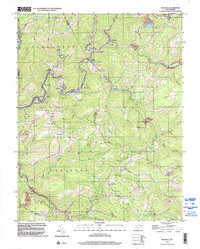
(8)- 1996 Map of Meadow Creek, 2002 Print
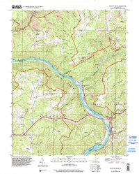 1996 Meadow Creek2002 Print · USGSThe New River Gorge area in the late twentieth century reveals a landscape of ridge-top mining and river-bottom settlements. Researchers can trace rural genealogy through the Oak Grove Ch, the Sandstone High Sch, and family landmarks near Sandstone Falls.
 - 1996 Map of Dorothy, 2002 Print
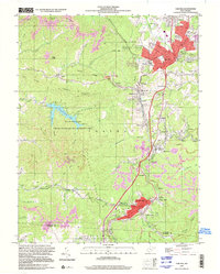
 1996 Dorothy2002 Print · USGSCoal mining and rail history dominate this West Virginia landscape in the late 1990s, where extraction infrastructure meets deep Appalachian hollows. Genealogists and researchers can trace local family sites like Union Cemetery, Township High School, and the Horse Creek Church.
 - 1996 Map of Pax, 2002 Print
 1996 Pax2002 Print · USGSWest Virginia coal country and the TOWN PLATEAU are documented here in the mid-nineties as modern highways intersected with traditional hollows. Researchers can locate dozens of family-named landmarks, from Workman Cem and Artie to the Toney Fork Ch.
 - 1996 Map of Whitesville, 2002 Print
 1996 Whitesville2002 Print · USGSThe West Virginia coalfields near the Boone and Raleigh county line are shown here in the late nineties as a dense network of valley settlements. Researchers can locate family landmarks like Jarrells Cem and trace the rail-and-river geography of Whitesville, Lindytown, and Montcoal.
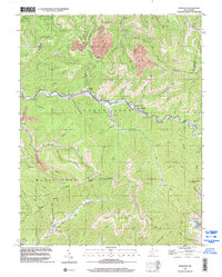
 - 1996 Map of Rhodell, 2003 Print
 1996 Rhodell2003 Print · USGSThe coalfields of southern West Virginia are captured here in the mid-1990s, showing a landscape defined by industry and steep-walled valleys. Researchers can trace the rail-and-river network connecting Amigo, Iroquois, and Rhodell alongside local landmarks like Union Ch and Milam Cem.
 - 1997 Map of Oak Hill, 2001 Print
 1997 Oak Hill2001 Print · USGSFayette County coal country is detailed here in the late twentieth century, showing the enduring footprint of mining and rail. Genealogists and historians can trace family roots through the High Lawn Mem Park, Price Hill, and Glen Jean.
 - 1997 Map of Thurmond, 2001 Print
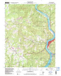
 1997 Thurmond2001 Print · USGSThe New River Gorge coal country is captured here during the late twentieth century, showing a landscape defined by industry and steep terrain. Genealogists and historians can trace the riverside settlements of Thurmond, Beury, and Sewell alongside coal-era infrastructure like strip mines and the Conveyor Tipple.
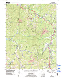
 - 1998 Map of Hinton, 2000 Print
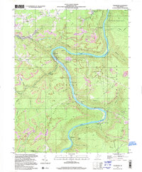
 1998 Hinton2000 Print · USGSThe confluence of the New River and Greenbrier River anchors this West Virginia landscape during the late twentieth century. Genealogists and local historians can trace the streets of Hinton, locate the Restwood Cemetery, and study the rail corridors of Barksdale and Avis.
End of results
Showing maps 1-8 of 8
Top cities of Raleigh County
- Beckley historical maps
- Mabscott historical maps
- Sophia historical maps
- Lester historical maps
- Rhodell historical maps
Frequently asked questions
- What are the different types of historical maps available for Raleigh County?
- What is the oldest map of Raleigh County?
- Where can I purchase historical maps of Raleigh County for my home or office?
- Where can I download high-res historical maps of Raleigh County?
- Are there historical topographic maps available for Raleigh County?
- Is there historical aerial imagery available for Raleigh County?
- Where are historical maps of Raleigh County sourced from?