1930s Maps of Raleigh County, West Virginia
Explore 4 historic maps of Raleigh County from the 1930s. These maps offer a rare glimpse into what life looked like during the 1930s — showing old roads, neighborhoods, homes, and landmarks that have changed or disappeared over time.
Whether you're researching your family's past, planning a metal detecting trip, or studying how Raleigh County's landscape evolved across the 1930s, these high-resolution maps are a powerful tool for exploring the history of this region.
- Focus on a specific era: All maps on this page are from the 1930s, giving you a focused view of this time period.
- See what’s changed: Compare century-old streets, trails, and buildings to today's modern landscape using overlays and satellite layers.
- Research with precision: Use these maps for genealogy, historical research, land use analysis, or educational projects.
- View, download, or print: Maps are fully viewable online in high resolution, and can be downloaded or printed for your own records.
Start exploring Raleigh County's history through authentic maps from the 1930s. This is your window into the past.
Raleigh County, WV maps
(4)- 1931 Map of Bald Knob
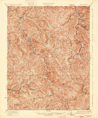 1931 Bald Knob1931 Print · USGSBoone and Logan counties are shown in the late twenties, an era when the coal and timber industries were driving the expansion of the Chesapeake and Ohio RR. Genealogists can trace family footprints at Bothwell Sch, Jackson (Blair PO), and Jerrolds Valley.2 unique versions available
 - 1932 Map of Beckley
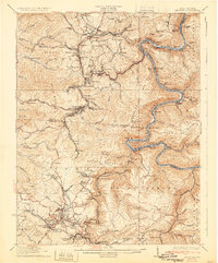 1932 Beckley1932 Print · USGSThe West Virginia coalfields are shown here at their industrial height in the early 1930s, centered on the rugged gorge of the New River. Genealogists and historians can trace the rail-and-river network connecting towns like Thurmond and Glen Jean or locate rural landmarks such as Brooklyn Finlow PO and Estuary School.2 unique versions available
 - 1932 Map of Flattop
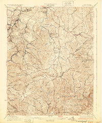 1932 Flattop1932 Print · USGSCoal and rail activity dominate the valleys of southern West Virginia in the early thirties. Trace the mining towns along the Virginian RR and locate local landmarks like Blue Jay Mine No 7, Vine Chapel, and Flattop School.2 unique versions available
 - 1932 Map of Eccles
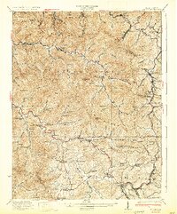 1932 Eccles1932 Print · USGSRaleigh County coal country during the height of the rail era features a dense network of mountain settlements and mining hollows. Trace family roots and vanished landmarks like Glen White, Lick Fork School, and the Sandlick Caperton School.3 unique versions available
End of results
Showing maps 1-4 of 4
Top cities of Raleigh County
- Beckley historical maps
- Mabscott historical maps
- Sophia historical maps
- Lester historical maps
- Rhodell historical maps
Frequently asked questions
- What are the different types of historical maps available for Raleigh County?
- What is the oldest map of Raleigh County?
- Where can I purchase historical maps of Raleigh County for my home or office?
- Where can I download high-res historical maps of Raleigh County?
- Are there historical topographic maps available for Raleigh County?
- Is there historical aerial imagery available for Raleigh County?
- Where are historical maps of Raleigh County sourced from?