1990s Maps of Monterville, West Virginia
Explore 1 historic maps of Monterville from the 1990s. These maps offer a rare glimpse into what life looked like during the 1990s — showing old roads, neighborhoods, homes, and landmarks that have changed or disappeared over time.
Whether you're researching your family's past, planning a metal detecting trip, or studying how Monterville's landscape evolved across the 1990s, these high-resolution maps are a powerful tool for exploring the history of this region.
- Focus on a specific era: All maps on this page are from the 1990s, giving you a focused view of this time period.
- See what’s changed: Compare century-old streets, trails, and buildings to today's modern landscape using overlays and satellite layers.
- Research with precision: Use these maps for genealogy, historical research, land use analysis, or educational projects.
- View, download, or print: Maps are fully viewable online in high resolution, and can be downloaded or printed for your own records.
Start exploring Monterville's history through authentic maps from the 1990s. This is your window into the past.
Monterville, WV maps
(1)- 1995 Map of Valley Head, 1998 Print
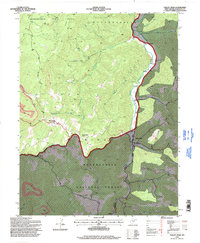 1995 Valley Head1998 Print · USGSThe Tygart Valley River headwaters near Valley Head were documented in the mid-1990s as the high-elevation forest lands transitioned. Genealogists can locate family landmarks like Stalnaker Cem and Ware Cem alongside small communities like Monterville and Blue Spring.
End of results
Showing maps 1-1 of 1
Top cities near Monterville
- Mill Creek historical maps
- Valley Bend historical maps
- East Dailey historical maps
- Huttonsville historical maps
- Valley Head historical maps
- Pickens historical maps
Frequently asked questions
- What are the different types of historical maps available for Monterville?
- What is the oldest map of Monterville?
- Where can I purchase historical maps of Monterville for my home or office?
- Where can I download high-res historical maps of Monterville?
- Are there historical topographic maps available for Monterville?
- Is there historical aerial imagery available for Monterville?
- Where are historical maps of Monterville sourced from?