1920s Maps of Dutchman, West Virginia
Explore 2 historic maps of Dutchman from the 1920s. These maps offer a rare glimpse into what life looked like during the 1920s — showing old roads, neighborhoods, homes, and landmarks that have changed or disappeared over time.
Whether you're researching your family's past, planning a metal detecting trip, or studying how Dutchman's landscape evolved across the 1920s, these high-resolution maps are a powerful tool for exploring the history of this region.
- Focus on a specific era: All maps on this page are from the 1920s, giving you a focused view of this time period.
- See what’s changed: Compare century-old streets, trails, and buildings to today's modern landscape using overlays and satellite layers.
- Research with precision: Use these maps for genealogy, historical research, land use analysis, or educational projects.
- View, download, or print: Maps are fully viewable online in high resolution, and can be downloaded or printed for your own records.
Start exploring Dutchman's history through authentic maps from the 1920s. This is your window into the past.
Dutchman, WV maps
(2)- 1924 Map of Harrisville, 1957 Print
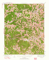 1924 Harrisville1957 Print · USGSRitchie County during the mid-1920s reveals a landscape of ridge-top schools and river-valley industry. Genealogists can trace family roots through numerous local landmarks like Silver Run Sta Donohue PO, Ritchie Mines, and Star Settlement.
 - 1926 Map of Harrisville
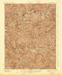 1926 Harrisville1926 Print · USGSRitchie County in the mid-twenties is a landscape of winding river valleys and bustling rail hubs like Cairo and Harrisville. Researchers can trace the heritage of remote hill communities through dozens of local landmarks like the Ritchie Mine, Donohue PO, and Star Settlement.
End of results
Showing maps 1-2 of 2
Top cities near Dutchman
- Harrisville historical maps
- Pennsboro historical maps
- Elizabeth historical maps
- Grantsville historical maps
- Ellenboro historical maps
- Cairo historical maps
See more
Frequently asked questions
- What are the different types of historical maps available for Dutchman?
- What is the oldest map of Dutchman?
- Where can I purchase historical maps of Dutchman for my home or office?
- Where can I download high-res historical maps of Dutchman?
- Are there historical topographic maps available for Dutchman?
- Is there historical aerial imagery available for Dutchman?
- Where are historical maps of Dutchman sourced from?