1960s Maps of Pennsboro, West Virginia
Explore 3 historic maps of Pennsboro from the 1960s. These maps offer a rare glimpse into what life looked like during the 1960s — showing old roads, neighborhoods, homes, and landmarks that have changed or disappeared over time.
Whether you're researching your family's past, planning a metal detecting trip, or studying how Pennsboro's landscape evolved across the 1960s, these high-resolution maps are a powerful tool for exploring the history of this region.
- Focus on a specific era: All maps on this page are from the 1960s, giving you a focused view of this time period.
- See what’s changed: Compare century-old streets, trails, and buildings to today's modern landscape using overlays and satellite layers.
- Research with precision: Use these maps for genealogy, historical research, land use analysis, or educational projects.
- View, download, or print: Maps are fully viewable online in high resolution, and can be downloaded or printed for your own records.
Start exploring Pennsboro's history through authentic maps from the 1960s. This is your window into the past.
Pennsboro, WV maps
(3)- 1961 Map of Clarksburg
 1961 Clarksburg1961 Print · USGSThe mid-century industrial and river landscapes of West Virginia and Ohio are detailed here, centered on the Ohio River. Researchers can trace the Baltimore and Ohio rail lines connecting towns like Parkersburg, Clarksburg, and Monongah.
 - 1961 Map of Ellenboro, 1962 Print
 1961 Ellenboro1962 Print · USGSRitchie County in the early sixties is captured here as a landscape of deep hollows and rail-side towns. Genealogists and historians can trace family locations near Ellenboro and Lamberton or find rural landmarks like Zoar Church and Mt Zion Church.3 unique versions available
 - 1961 Map of Pennsboro, 1962 Print
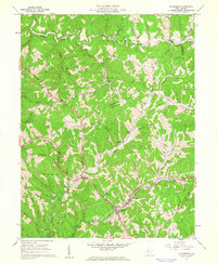
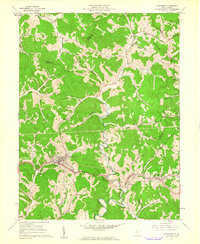 1961 Pennsboro1962 Print · USGSRitchie County's rail and river valleys come alive in the early sixties as the energy industry shapes the landscape around Pennsboro. Trace family roots and local industry through features like the Baltimore and Ohio RR, Mole Hill Chapel, and the Buck Run Sch.4 unique versions available
End of results
Showing maps 1-3 of 3
Top cities near Pennsboro
- Harrisville historical maps
- Middlebourne historical maps
- West Union historical maps
- Ellenboro historical maps
- Cairo historical maps
- Pullman historical maps
See more
Frequently asked questions
- What are the different types of historical maps available for Pennsboro?
- What is the oldest map of Pennsboro?
- Where can I purchase historical maps of Pennsboro for my home or office?
- Where can I download high-res historical maps of Pennsboro?
- Are there historical topographic maps available for Pennsboro?
- Is there historical aerial imagery available for Pennsboro?
- Where are historical maps of Pennsboro sourced from?