1900s (20th Century) Maps of Pullman, West Virginia
Explore 9 historic maps of Pullman from the 1900s (20th Century). These maps offer a rare glimpse into what life looked like during the 1900s — showing old roads, neighborhoods, homes, and landmarks that have changed or disappeared over time.
Whether you're researching your family's past, planning a metal detecting trip, or studying how Pullman's landscape evolved across the 1900s, these high-resolution maps are a powerful tool for exploring the history of this region.
- Focus on a specific era: All maps on this page are from the 1900s, giving you a focused view of this time period.
- See what’s changed: Compare century-old streets, trails, and buildings to today's modern landscape using overlays and satellite layers.
- Research with precision: Use these maps for genealogy, historical research, land use analysis, or educational projects.
- View, download, or print: Maps are fully viewable online in high resolution, and can be downloaded or printed for your own records.
Start exploring Pullman's history through authentic maps from the 1900s. This is your window into the past.
Pullman, WV maps
(9)- 1906 Map of Holbrook
 1906 Holbrook1906 Print · USGSRitchie County and the surrounding highlands are captured here at the dawn of the twentieth century. Genealogists can trace family names and early homesteads near Burnt House, the Staunton and Parkersburg Pike, and the village of Pullman.2 unique versions available
 - 1924 Map of Holbrook, 1961 Print
 1924 Holbrook1961 Print · USGSNorth-central West Virginia at the height of its rural settlement density reveals a landscape of ridge-top knobs and narrow hollows. Genealogists and historians can trace dozens of family-named landmarks and local institutions, from Mt Union Church to the many schools like Alum Fork School and Moonrise School.
 - 1926 Map of Holbrook
 1926 Holbrook1926 Print · USGSRitchie and Gilmer Counties are shown here in the mid-1920s, before modern highways altered these mountain valleys. Genealogists can trace family names across dozens of rural institutions, from Fairview Church to the Coal Alum Fork School.2 unique versions available
 - 1949 Map of Clarksburg
 1949 Clarksburg1949 Print · USGSThe upper Ohio River valley and the industrial heart of West Virginia come into focus during this post-war period. Genealogists and researchers can trace the rail corridors of the Baltimore and Ohio and locate centers like Fairmont, Grafton, and Waynesburg.
 - 1956 Map of Clarksburg, 1966 Print
 1956 Clarksburg1966 Print · USGSThe Ohio River valley and the industrial heart of West Virginia are seen here in the mid-1950s as rail and river commerce thrived. Researchers can trace historic transport lines like the Baltimore and Ohio RR and locate ancestral homes in Clarksburg, Moundsville, or Parkersburg.2 unique versions available
 - 1961 Map of Clarksburg
 1961 Clarksburg1961 Print · USGSThe mid-century industrial and river landscapes of West Virginia and Ohio are detailed here, centered on the Ohio River. Researchers can trace the Baltimore and Ohio rail lines connecting towns like Parkersburg, Clarksburg, and Monongah.
 - 1964 Map of Pullman, 1966 Print
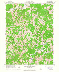 1964 Pullman1966 Print · USGSRitchie County's ridgelines and river forks are captured here in the mid-1960s, centered on the rural hub of Pullman. Researchers can trace old family burial grounds like Taylor Cem and remote country landmarks from Five Forks to Mt Zion Ch.2 unique versions available
 - 1982 Map of Clarksburg, 1983 Print
 1982 Clarksburg1983 Print · USGSNorth Central West Virginia in the early eighties reveals a landscape deeply connected to its coal and gas resources. Genealogists and researchers can trace family landmarks and historical settlements from Clarksburg to Buckhannon, or locate sites like Quiet Dell and Watters Smith Memorial State Park.
 - 1988 Map of Clarksburg, 1989 Print
 1988 Clarksburg1989 Print · USGSThe central Appalachians are documented in detail during the late eighties, showing the industrial and river-based economies of West Virginia, Ohio, and Pennsylvania. Researchers can trace historic rail routes like the B & O RR and locate river towns from St Marys to Parkersburg.
End of results
Showing maps 1-9 of 9
Top cities near Pullman
- Harrisville historical maps
- Pennsboro historical maps
- West Union historical maps
- Ellenboro historical maps
- Cairo historical maps
- Auburn historical maps
Frequently asked questions
- What are the different types of historical maps available for Pullman?
- What is the oldest map of Pullman?
- Where can I purchase historical maps of Pullman for my home or office?
- Where can I download high-res historical maps of Pullman?
- Are there historical topographic maps available for Pullman?
- Is there historical aerial imagery available for Pullman?
- Where are historical maps of Pullman sourced from?