1900-1909 Maps of Flint Town, West Virginia
Explore 2 historic maps of Flint Town from 1900-1909. These maps offer a rare glimpse into what life looked like during the 1900s — showing old roads, neighborhoods, homes, and landmarks that have changed or disappeared over time.
Whether you're researching your family's past, planning a metal detecting trip, or studying how Flint Town's landscape evolved across the 1900s, these high-resolution maps are a powerful tool for exploring the history of this region.
- Focus on a specific era: All maps on this page are from the 1900s, giving you a focused view of this time period.
- See what’s changed: Compare century-old streets, trails, and buildings to today's modern landscape using overlays and satellite layers.
- Research with precision: Use these maps for genealogy, historical research, land use analysis, or educational projects.
- View, download, or print: Maps are fully viewable online in high resolution, and can be downloaded or printed for your own records.
Start exploring Flint Town's history through authentic maps from the 1900s. This is your window into the past.
Flint Town, WV maps
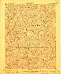
(2)- 1906 Map of Walton, 1961 Print
 1906 Walton1961 Print · USGSRoane County at the dawn of the twentieth century shows a landscape of river-fed valleys and milling hamlets. Genealogists can trace family roots through historic settlements like Walton, Gandeeville, and Looneyville or locate long-standing landmarks like Mt Hermon Church.
 - 1907 Map of Walton
 1907 Walton1907 Print · USGSRoane County at the dawn of the twentieth century is a landscape of winding river valleys and isolated hilltop settlements. Genealogists and historians can trace family-named landmarks and early industry at Shamblings Mills, Osbornes Mills, and Mt Hermon Church.3 unique versions available
End of results
Showing maps 1-2 of 2
Top cities near Flint Town
Frequently asked questions
- What are the different types of historical maps available for Flint Town?
- What is the oldest map of Flint Town?
- Where can I purchase historical maps of Flint Town for my home or office?
- Where can I download high-res historical maps of Flint Town?
- Are there historical topographic maps available for Flint Town?
- Is there historical aerial imagery available for Flint Town?
- Where are historical maps of Flint Town sourced from?