1960s Maps of Hinton, West Virginia
Explore 3 historic maps of Hinton from the 1960s. These maps offer a rare glimpse into what life looked like during the 1960s — showing old roads, neighborhoods, homes, and landmarks that have changed or disappeared over time.
Whether you're researching your family's past, planning a metal detecting trip, or studying how Hinton's landscape evolved across the 1960s, these high-resolution maps are a powerful tool for exploring the history of this region.
- Focus on a specific era: All maps on this page are from the 1960s, giving you a focused view of this time period.
- See what’s changed: Compare century-old streets, trails, and buildings to today's modern landscape using overlays and satellite layers.
- Research with precision: Use these maps for genealogy, historical research, land use analysis, or educational projects.
- View, download, or print: Maps are fully viewable online in high resolution, and can be downloaded or printed for your own records.
Start exploring Hinton's history through authentic maps from the 1960s. This is your window into the past.
Hinton, WV maps
(3)- 1961 Map of Bluefield
 1961 Bluefield1961 Print · USGSThe coalfields and mountain ridges of southern West Virginia and southwest Virginia are captured in the early sixties. Genealogists can trace family ties through rail-linked towns like Princeton and Richlands or along the shores of Bluestone Reservoir.
 - 1968 Map of Talcott, 1971 Print
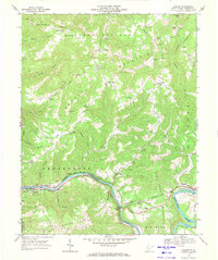 1968 Talcott1971 Print · USGSSummers County follows the winding Greenbrier River in the late sixties, where the railroad era and rural mountain life converged. Genealogists can trace family footprints at Talcott, the Chestnut Mountain School, and the Little Bend Tunnel.2 unique versions available
 - 1968 Map of Hinton, 1971 Print
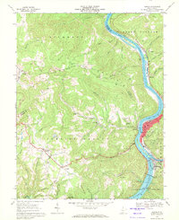 1968 Hinton1971 Print · USGSThe rail and river geography of the New River Valley is on full display here in the late sixties. Genealogists and local historians can trace the foundations of Hinton and Avis, or locate landmarks like the White Oak Mine and Restwood Cemetery.2 unique versions available
End of results
Showing maps 1-3 of 3
Top cities near Hinton
Top neighborhoods of Hinton
Frequently asked questions
- What are the different types of historical maps available for Hinton?
- What is the oldest map of Hinton?
- Where can I purchase historical maps of Hinton for my home or office?
- Where can I download high-res historical maps of Hinton?
- Are there historical topographic maps available for Hinton?
- Is there historical aerial imagery available for Hinton?
- Where are historical maps of Hinton sourced from?