1970s Maps of Heavener Grove, West Virginia
Explore 2 historic maps of Heavener Grove from the 1970s. These maps offer a rare glimpse into what life looked like during the 1970s — showing old roads, neighborhoods, homes, and landmarks that have changed or disappeared over time.
Whether you're researching your family's past, planning a metal detecting trip, or studying how Heavener Grove's landscape evolved across the 1970s, these high-resolution maps are a powerful tool for exploring the history of this region.
- Focus on a specific era: All maps on this page are from the 1970s, giving you a focused view of this time period.
- See what’s changed: Compare century-old streets, trails, and buildings to today's modern landscape using overlays and satellite layers.
- Research with precision: Use these maps for genealogy, historical research, land use analysis, or educational projects.
- View, download, or print: Maps are fully viewable online in high resolution, and can be downloaded or printed for your own records.
Start exploring Heavener Grove's history through authentic maps from the 1970s. This is your window into the past.
Heavener Grove, WV maps
(2)- 1974 Map of Buckhannon, 1989 Print
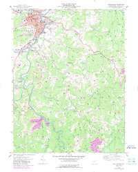 1974 Buckhannon1989 Print · USGSUpshur County in the mid-seventies reveals a river-centered landscape where the city of Buckhannon meets the coal-bearing hills. Researchers can trace the legacy of local institutions like West Virginia Wesleyan College or locate vanished mining sites near Hampton and Tallmansville.
 - 1977 Map of Buckhannon
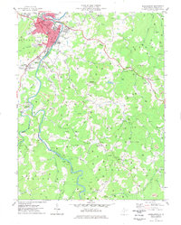 1977 Buckhannon1977 Print · USGSBuckhannon and the surrounding Upshur County hills are captured here in the mid-1970s, showing a landscape defined by the Tygart Valley's rail and river networks. Researchers can pinpoint historic institutions like West Virginia Wesleyan College and rural landmarks such as Ours Mill (Site) and Tallmansville.
End of results
Showing maps 1-2 of 2
Top cities near Heavener Grove
- Buckhannon historical maps
- Philippi historical maps
- West Milford historical maps
- Lost Creek historical maps
- Junior historical maps
- Norton historical maps
See more
Frequently asked questions
- What are the different types of historical maps available for Heavener Grove?
- What is the oldest map of Heavener Grove?
- Where can I purchase historical maps of Heavener Grove for my home or office?
- Where can I download high-res historical maps of Heavener Grove?
- Are there historical topographic maps available for Heavener Grove?
- Is there historical aerial imagery available for Heavener Grove?
- Where are historical maps of Heavener Grove sourced from?