1910s Maps of Heavener Grove, West Virginia
Explore 2 historic maps of Heavener Grove from the 1910s. These maps offer a rare glimpse into what life looked like during the 1910s — showing old roads, neighborhoods, homes, and landmarks that have changed or disappeared over time.
Whether you're researching your family's past, planning a metal detecting trip, or studying how Heavener Grove's landscape evolved across the 1910s, these high-resolution maps are a powerful tool for exploring the history of this region.
- Focus on a specific era: All maps on this page are from the 1910s, giving you a focused view of this time period.
- See what’s changed: Compare century-old streets, trails, and buildings to today's modern landscape using overlays and satellite layers.
- Research with precision: Use these maps for genealogy, historical research, land use analysis, or educational projects.
- View, download, or print: Maps are fully viewable online in high resolution, and can be downloaded or printed for your own records.
Start exploring Heavener Grove's history through authentic maps from the 1910s. This is your window into the past.
Heavener Grove, WV maps
(2)- 1912 Map of Sago
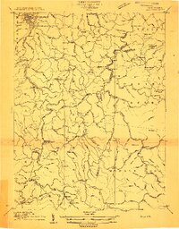 1912 Sago1912 Print · USGSThe Buckhannon River valley was a bustling corridor for the Baltimore and Ohio Railroad in the early twentieth century. Genealogists can trace family names and remote post offices at Beans Mill Indian Camp PO, Sago, and Kingsville PO.4 unique versions available
 - 1914 Map of Sago
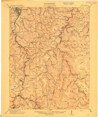 1914 Sago1914 Print · USGSUpshur and Randolph counties thrive as centers of the timber and rail trade during the early twentieth century. Genealogists can trace family names through dozens of rural landmarks like Beans Mill Indian Camp, Tallmansville, and the Hanging Run School.4 unique versions available
End of results
Showing maps 1-2 of 2
Top cities near Heavener Grove
- Buckhannon historical maps
- Philippi historical maps
- West Milford historical maps
- Lost Creek historical maps
- Junior historical maps
- Norton historical maps
See more
Frequently asked questions
- What are the different types of historical maps available for Heavener Grove?
- What is the oldest map of Heavener Grove?
- Where can I purchase historical maps of Heavener Grove for my home or office?
- Where can I download high-res historical maps of Heavener Grove?
- Are there historical topographic maps available for Heavener Grove?
- Is there historical aerial imagery available for Heavener Grove?
- Where are historical maps of Heavener Grove sourced from?