1960s Maps of Cherry Falls, West Virginia
Explore 2 historic maps of Cherry Falls from the 1960s. These maps offer a rare glimpse into what life looked like during the 1960s — showing old roads, neighborhoods, homes, and landmarks that have changed or disappeared over time.
Whether you're researching your family's past, planning a metal detecting trip, or studying how Cherry Falls's landscape evolved across the 1960s, these high-resolution maps are a powerful tool for exploring the history of this region.
- Focus on a specific era: All maps on this page are from the 1960s, giving you a focused view of this time period.
- See what’s changed: Compare century-old streets, trails, and buildings to today's modern landscape using overlays and satellite layers.
- Research with precision: Use these maps for genealogy, historical research, land use analysis, or educational projects.
- View, download, or print: Maps are fully viewable online in high resolution, and can be downloaded or printed for your own records.
Start exploring Cherry Falls's history through authentic maps from the 1960s. This is your window into the past.
Cherry Falls, WV maps
(2)- 1961 Map of Charleston
 1961 Charleston1961 Print · USGSWest Virginia's capital region and the highlands to the east are shown in detail during the early sixties. Genealogists and historians can trace rail networks like the Baltimore and Ohio RR and find early state parks such as Watoga State Park.
 - 1966 Map of Webster Springs, 1970 Print
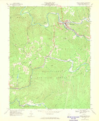 1966 Webster Springs1970 Print · USGSWebster County in the mid-1960s was a rugged network of riverfront settlements and mountain coal operations. Genealogists and historians can trace the Baltimore and Ohio rail lines and locate landmarks like Camp Caesar, Skidmore Crossing, and Pleasant Ridge Ch.2 unique versions available
End of results
Showing maps 1-2 of 2
Top cities near Cherry Falls
- Addison (Webster Springs) historical maps
- Webster Springs historical maps
- Cowen historical maps
- Pickens historical maps
Frequently asked questions
- What are the different types of historical maps available for Cherry Falls?
- What is the oldest map of Cherry Falls?
- Where can I purchase historical maps of Cherry Falls for my home or office?
- Where can I download high-res historical maps of Cherry Falls?
- Are there historical topographic maps available for Cherry Falls?
- Is there historical aerial imagery available for Cherry Falls?
- Where are historical maps of Cherry Falls sourced from?