1910s Maps of Wainville, West Virginia
Explore 2 historic maps of Wainville from the 1910s. These maps offer a rare glimpse into what life looked like during the 1910s — showing old roads, neighborhoods, homes, and landmarks that have changed or disappeared over time.
Whether you're researching your family's past, planning a metal detecting trip, or studying how Wainville's landscape evolved across the 1910s, these high-resolution maps are a powerful tool for exploring the history of this region.
- Focus on a specific era: All maps on this page are from the 1910s, giving you a focused view of this time period.
- See what’s changed: Compare century-old streets, trails, and buildings to today's modern landscape using overlays and satellite layers.
- Research with precision: Use these maps for genealogy, historical research, land use analysis, or educational projects.
- View, download, or print: Maps are fully viewable online in high resolution, and can be downloaded or printed for your own records.
Start exploring Wainville's history through authentic maps from the 1910s. This is your window into the past.
Wainville, WV maps
(2)- 1915 Map of Cowen
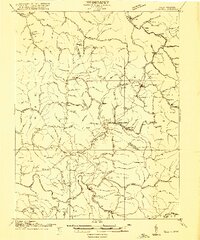 1915 Cowen1915 Print · USGSCentral West Virginia's timber and coal corridors are captured here during a period of rapid development. Trace ancestral roots at Marcus PO or Woodbine PO, and locate long-lost rural sites like the Cottle Glade School and Myspi Church.3 unique versions available
 - 1917 Map of Cowen
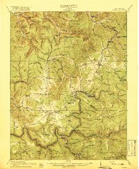 1917 Cowen1917 Print · USGSThe central West Virginia highlands are shown here just after the peak of the early industrial era, when rail lines and timber camps dominated the river valleys. Genealogists can locate dozens of country schoolhouses like Reynolds School and trace long-lost post offices at Halo Sta Marcus PO or Cranberry Woodbine PO.3 unique versions available
End of results
Showing maps 1-2 of 2
Top cities near Wainville
- Craigsville historical maps
- Sutton historical maps
- Gassaway historical maps
- Addison (Webster Springs) historical maps
- Webster Springs historical maps
- Cowen historical maps
See more
Frequently asked questions
- What are the different types of historical maps available for Wainville?
- What is the oldest map of Wainville?
- Where can I purchase historical maps of Wainville for my home or office?
- Where can I download high-res historical maps of Wainville?
- Are there historical topographic maps available for Wainville?
- Is there historical aerial imagery available for Wainville?
- Where are historical maps of Wainville sourced from?