1920s Maps of Jacksonburg, West Virginia
Explore 2 historic maps of Jacksonburg from the 1920s. These maps offer a rare glimpse into what life looked like during the 1920s — showing old roads, neighborhoods, homes, and landmarks that have changed or disappeared over time.
Whether you're researching your family's past, planning a metal detecting trip, or studying how Jacksonburg's landscape evolved across the 1920s, these high-resolution maps are a powerful tool for exploring the history of this region.
- Focus on a specific era: All maps on this page are from the 1920s, giving you a focused view of this time period.
- See what’s changed: Compare century-old streets, trails, and buildings to today's modern landscape using overlays and satellite layers.
- Research with precision: Use these maps for genealogy, historical research, land use analysis, or educational projects.
- View, download, or print: Maps are fully viewable online in high resolution, and can be downloaded or printed for your own records.
Start exploring Jacksonburg's history through authentic maps from the 1920s. This is your window into the past.
Jacksonburg, WV maps
(2)- 1924 Map of Littleton, 1957 Print
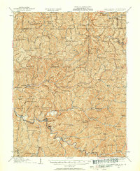 1924 Littleton1957 Print · USGSWetzel County at the height of the rail era shows a landscape densely packed with small-town life and rural industry. Genealogists can trace family names and locations at Scheidler Run Church, Otter Den School, and along the Baltimore and Ohio line.
 - 1926 Map of Littleton
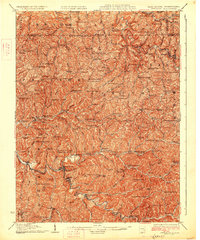 1926 Littleton1926 Print · USGSWetzel County in the mid-twenties is a landscape of high ridges and deep hollows where community life centered on countless rural schools and churches. Trace family roots and vanished landmarks from Saint Joseph down to Smithfield, including Higgins Chapel and Antioch School.2 unique versions available
End of results
Showing maps 1-2 of 2
Top cities near Jacksonburg
- New Martinsville historical maps
- Pine Grove historical maps
- Clarington historical maps
- Hundred historical maps
- Littleton historical maps
- Smithfield historical maps
Frequently asked questions
- What are the different types of historical maps available for Jacksonburg?
- What is the oldest map of Jacksonburg?
- Where can I purchase historical maps of Jacksonburg for my home or office?
- Where can I download high-res historical maps of Jacksonburg?
- Are there historical topographic maps available for Jacksonburg?
- Is there historical aerial imagery available for Jacksonburg?
- Where are historical maps of Jacksonburg sourced from?