1960s Maps of Munday, West Virginia
Explore 2 historic maps of Munday from the 1960s. These maps offer a rare glimpse into what life looked like during the 1960s — showing old roads, neighborhoods, homes, and landmarks that have changed or disappeared over time.
Whether you're researching your family's past, planning a metal detecting trip, or studying how Munday's landscape evolved across the 1960s, these high-resolution maps are a powerful tool for exploring the history of this region.
- Focus on a specific era: All maps on this page are from the 1960s, giving you a focused view of this time period.
- See what’s changed: Compare century-old streets, trails, and buildings to today's modern landscape using overlays and satellite layers.
- Research with precision: Use these maps for genealogy, historical research, land use analysis, or educational projects.
- View, download, or print: Maps are fully viewable online in high resolution, and can be downloaded or printed for your own records.
Start exploring Munday's history through authentic maps from the 1960s. This is your window into the past.
Munday, WV maps
(2)- 1961 Map of Clarksburg
 1961 Clarksburg1961 Print · USGSThe mid-century industrial and river landscapes of West Virginia and Ohio are detailed here, centered on the Ohio River. Researchers can trace the Baltimore and Ohio rail lines connecting towns like Parkersburg, Clarksburg, and Monongah.
 - 1964 Map of Macfarlan, 1966 Print
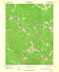 1964 Macfarlan1966 Print · USGSRitchie County’s winding river valleys were defined by timber and fuel extraction in the mid-1960s. Genealogists and researchers can trace local family lineages through remote landmarks like Hartley Sch, Nutter Cem, and the river community of Macfarlan.3 unique versions available
End of results
Showing maps 1-2 of 2
Top cities near Munday
- Spencer historical maps
- Harrisville historical maps
- Elizabeth historical maps
- Grantsville historical maps
- Cairo historical maps
- Reedy historical maps
Frequently asked questions
- What are the different types of historical maps available for Munday?
- What is the oldest map of Munday?
- Where can I purchase historical maps of Munday for my home or office?
- Where can I download high-res historical maps of Munday?
- Are there historical topographic maps available for Munday?
- Is there historical aerial imagery available for Munday?
- Where are historical maps of Munday sourced from?