1960s Maps of Parkersburg, West Virginia
Explore 3 historic maps of Parkersburg from the 1960s. These maps offer a rare glimpse into what life looked like during the 1960s — showing old roads, neighborhoods, homes, and landmarks that have changed or disappeared over time.
Whether you're researching your family's past, planning a metal detecting trip, or studying how Parkersburg's landscape evolved across the 1960s, these high-resolution maps are a powerful tool for exploring the history of this region.
- Focus on a specific era: All maps on this page are from the 1960s, giving you a focused view of this time period.
- See what’s changed: Compare century-old streets, trails, and buildings to today's modern landscape using overlays and satellite layers.
- Research with precision: Use these maps for genealogy, historical research, land use analysis, or educational projects.
- View, download, or print: Maps are fully viewable online in high resolution, and can be downloaded or printed for your own records.
Start exploring Parkersburg's history through authentic maps from the 1960s. This is your window into the past.
Parkersburg, WV maps
(3)- 1961 Map of Clarksburg
 1961 Clarksburg1961 Print · USGSThe mid-century industrial and river landscapes of West Virginia and Ohio are detailed here, centered on the Ohio River. Researchers can trace the Baltimore and Ohio rail lines connecting towns like Parkersburg, Clarksburg, and Monongah.
 - 1961 Map of South Parkersburg, 1963 Print
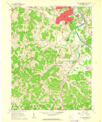 1961 South Parkersburg1963 Print · USGSSouth Parkersburg and the surrounding Wood County ridges are captured here during a period of steady mid-century growth. Genealogists and local researchers can trace family landmarks like Mathews Cem and Gihon Ch, or follow the Baltimore and Ohio rail line.3 unique versions available
 - 1969 Map of Parkersburg, 1971 Print
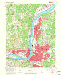 1969 Parkersburg1971 Print · USGSThe Ohio River valley thrives in the late 1960s as Parkersburg and Vienna expand their industrial and residential footprints. Genealogists and historians can trace local landmarks like Stewart Air Park, Blennerhassett Island, and St Josephs Hospital at this pivotal moment of growth.5 unique versions available
End of results
Showing maps 1-3 of 3
Top cities near Parkersburg
- Marietta historical maps
- Vienna historical maps
- Belpre historical maps
- Blennerhassett historical maps
- Williamstown historical maps
- Dunham historical maps
See more
Top neighborhoods of Parkersburg
- South Parkersburg historical maps
- North Parkersburg historical maps
- Riverside historical maps
- Tavennersville historical maps
- Fairview Heights historical maps
- Lauckport historical maps
See more
Frequently asked questions
- What are the different types of historical maps available for Parkersburg?
- What is the oldest map of Parkersburg?
- Where can I purchase historical maps of Parkersburg for my home or office?
- Where can I download high-res historical maps of Parkersburg?
- Are there historical topographic maps available for Parkersburg?
- Is there historical aerial imagery available for Parkersburg?
- Where are historical maps of Parkersburg sourced from?