1960s Maps of Mullens, West Virginia
Explore 3 historic maps of Mullens from the 1960s. These maps offer a rare glimpse into what life looked like during the 1960s — showing old roads, neighborhoods, homes, and landmarks that have changed or disappeared over time.
Whether you're researching your family's past, planning a metal detecting trip, or studying how Mullens's landscape evolved across the 1960s, these high-resolution maps are a powerful tool for exploring the history of this region.
- Focus on a specific era: All maps on this page are from the 1960s, giving you a focused view of this time period.
- See what’s changed: Compare century-old streets, trails, and buildings to today's modern landscape using overlays and satellite layers.
- Research with precision: Use these maps for genealogy, historical research, land use analysis, or educational projects.
- View, download, or print: Maps are fully viewable online in high resolution, and can be downloaded or printed for your own records.
Start exploring Mullens's history through authentic maps from the 1960s. This is your window into the past.
Mullens, WV maps
(3)- 1961 Map of Bluefield
 1961 Bluefield1961 Print · USGSThe coalfields and mountain ridges of southern West Virginia and southwest Virginia are captured in the early sixties. Genealogists can trace family ties through rail-linked towns like Princeton and Richlands or along the shores of Bluestone Reservoir.
 - 1967 Map of Rhodell, 1970 Print
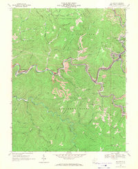
 1967 Rhodell1970 Print · USGSThe West Virginia coalfields are in full operation during the late 1960s, with railroads and mining camps lining the river valleys. Genealogists and historians can trace rail-side communities like Rhodell, Amigo, and Stonecoal Junction or locate landmarks such as the Drive-in Theater and Mt Pisgah Ch.2 unique versions available
 - 1967 Map of Mullens, 1971 Print
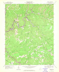
 1967 Mullens1971 Print · USGSThe West Virginia coalfields are in full operation during the late sixties as the Norfolk and Western railway snakes through the Guyandotte River valley. Trace family roots and local industry in Mullens, Itmann, and Tralee, or locate rural landmarks like Slab Fork Sch and Bower Cem.2 unique versions available
End of results
Showing maps 1-3 of 3
Top cities near Mullens
- Beckley historical maps
- Welch historical maps
- Oceana historical maps
- Mabscott historical maps
- Sophia historical maps
- Gary historical maps
See more
Top neighborhoods of Mullens
Frequently asked questions
- What are the different types of historical maps available for Mullens?
- What is the oldest map of Mullens?
- Where can I purchase historical maps of Mullens for my home or office?
- Where can I download high-res historical maps of Mullens?
- Are there historical topographic maps available for Mullens?
- Is there historical aerial imagery available for Mullens?
- Where are historical maps of Mullens sourced from?