1970s Maps of Ashland County, Wisconsin
Explore 9 historic maps of Ashland County from the 1970s. These maps offer a rare glimpse into what life looked like during the 1970s — showing old roads, neighborhoods, homes, and landmarks that have changed or disappeared over time.
Whether you're researching your family's past, planning a metal detecting trip, or studying how Ashland County's landscape evolved across the 1970s, these high-resolution maps are a powerful tool for exploring the history of this region.
- Focus on a specific era: All maps on this page are from the 1970s, giving you a focused view of this time period.
- See what’s changed: Compare century-old streets, trails, and buildings to today's modern landscape using overlays and satellite layers.
- Research with precision: Use these maps for genealogy, historical research, land use analysis, or educational projects.
- View, download, or print: Maps are fully viewable online in high resolution, and can be downloaded or printed for your own records.
Start exploring Ashland County's history through authentic maps from the 1970s. This is your window into the past.
Ashland County, WI maps
(9)- 1970 Map of Butternut Lake, 1972 Print
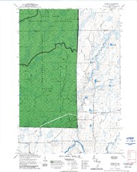
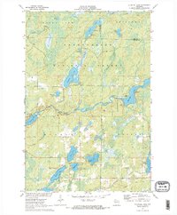
 1970 Butternut Lake1972 Print · USGSThe Price County timberlands and lakefronts are frozen in time just as the seventies began. Researchers can trace the Chicago and North Western rail route or locate local landmarks like the Kennedy Lookout Tower and Pixley Dam.
 - 1970 Map of Kennedy, 1972 Print
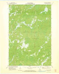
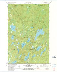
 1970 Kennedy1972 Print · USGSSawyer and Ashland counties are shown in the early 1970s as centers of Wisconsin timber and recreation. Researchers can locate the settlement of Kennedy, follow the Tuscobia State Forest Trail, and trace the shoreline of Lake Alice.3 unique versions available
 - 1971 Map of Clam Lake SE, 1973 Print
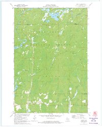
 1971 Clam Lake SE1973 Print · USGSAshland County's northwoods were a dense wilderness of complex river systems in the early 1970s. Explorers and outdoorsmen can trace the marshy headwaters of the Moose River, Black Creek, and the isolated reaches of Hell Hole Creek through the forest.2 unique versions available
 - 1971 Map of Clam Lake NE, 1973 Print
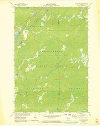
 1971 Clam Lake NE1973 Print · USGSAshland County's timberlands and glacial lakes are captured here in the early 1970s, showing a landscape shaped by conservation and former industry. Researchers can trace the Old RR Grade or locate historic water features like Dead Horse Slough and Moquah Lake.
 - 1971 Map of Loretta, 1973 Print
 1971 Loretta1973 Print · USGSNorthern Sawyer County was a haven for timber and recreation in the early seventies, dominated by the sprawling Chequamegon National Forest. Researchers can locate historic structures in Loretta and Draper, or trace the winding course of the Brunet River and the Snowmobile Trail.2 unique versions available
 - 1971 Map of Clam Lake SW, 1973 Print
 1971 Clam Lake SW1973 Print · USGSSawyer and Ashland Counties are shown in the early seventies, a period when the timberlands and waterways remained largely undeveloped. Genealogists and outdoorsmen can trace the drainage of the West Fork Chippewa River past Shanagolden and Kelly Lake.2 unique versions available
 - 1971 Map of Blaisdell Lake, 1973 Print
 1971 Blaisdell Lake1973 Print · USGSSawyer County’s Northwoods were a secluded network of glacial lakes and river bends in the early seventies. Genealogists and local historians can trace legacy sites like the Wa-Ha-Kee Church Camp and Glenwood Camp or the path of the regional Snowmobile Trail.2 unique versions available
 - 1971 Map of Clam Lake, 1990 Print
 1971 Clam Lake1990 Print · USGSThe Northwoods of Ashland and Bayfield Counties come alive in this early 1970s survey of the lake-studded forestry landscape. Researchers can locate the Clam Lake Lookout Tower, trace burials at Wildwood Cem, and find the Job Corps Camp near Chippewa Lake.
 - 1978 Map of Outer Island
 1978 Outer Island1978 Print · USGSThe Apostle Islands archipelago and the vast expanse of Lake Superior are shown in the late seventies. Researchers can trace maritime landmarks like the Outer Island Light, explore island terrain from Bear Island to Cat Island, and locate the old Landing Strip.
End of results
Showing maps 1-9 of 9
Top cities of Ashland County
- Ashland historical maps
- Mellen historical maps
- Butternut historical maps
- La Pointe historical maps
- Shanagolden historical maps
Frequently asked questions
- What are the different types of historical maps available for Ashland County?
- What is the oldest map of Ashland County?
- Where can I purchase historical maps of Ashland County for my home or office?
- Where can I download high-res historical maps of Ashland County?
- Are there historical topographic maps available for Ashland County?
- Is there historical aerial imagery available for Ashland County?
- Where are historical maps of Ashland County sourced from?