1960s Maps of Ashland County, Wisconsin
Explore 34 historic maps of Ashland County from the 1960s. These maps offer a rare glimpse into what life looked like during the 1960s — showing old roads, neighborhoods, homes, and landmarks that have changed or disappeared over time.
Whether you're researching your family's past, planning a metal detecting trip, or studying how Ashland County's landscape evolved across the 1960s, these high-resolution maps are a powerful tool for exploring the history of this region.
- Focus on a specific era: All maps on this page are from the 1960s, giving you a focused view of this time period.
- See what’s changed: Compare century-old streets, trails, and buildings to today's modern landscape using overlays and satellite layers.
- Research with precision: Use these maps for genealogy, historical research, land use analysis, or educational projects.
- View, download, or print: Maps are fully viewable online in high resolution, and can be downloaded or printed for your own records.
Start exploring Ashland County's history through authentic maps from the 1960s. This is your window into the past.
Ashland County, WI maps
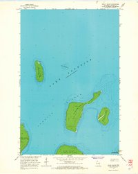
(34)- 1963 Map of Outer Island, 1965 Print
 1963 Outer Island1965 Print · USGSThe Apostle Islands' easternmost reaches are captured here in the early 1960s, showing the remote northern lighthouse and surrounding lake depths. Trace the island's isolation through landmarks like the Outer Island Light, Austad Bay, and Sand Point.2 unique versions available
 - 1963 Map of Cat Island, 1965 Print
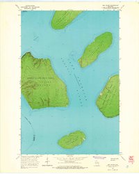
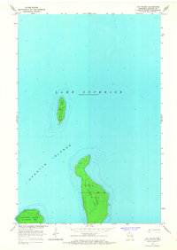 1963 Cat Island1965 Print · USGSThe remote archipelago of the Apostle Islands is captured here in the mid-1960s. Researchers can trace the shoreline elevations and lake soundings surrounding Cat Island, North Twin Island, and the edge of Ironwood Island.2 unique versions available
 - 1963 Map of Michigan Island, 1965 Print
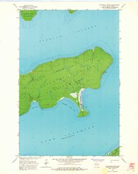
 1963 Michigan Island1965 Print · USGSThe Apostle Islands of Lake Superior are captured in this mid-sixties survey focusing on the maritime landscape of Ashland County. Researchers can locate critical navigational aids like Michigan Island Light and Gull Island Light while tracing the contours of Michigan Island.
 - 1963 Map of Rocky Island, 1965 Print
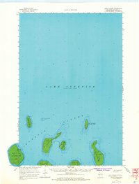 1963 Rocky Island1965 Print · USGSThe Apostle Islands are documented in the early sixties as isolated outposts within La Pointe Twp. Maritime researchers can trace navigational aids like the Light on Devils Island or the remote Landing Strip on South Twin Island.2 unique versions available
 - 1963 Map of Outer Island, 1965 Print
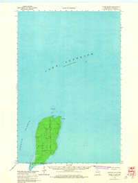
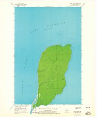 1963 Outer Island1965 Print · USGSOuter Island stands as a remote sentinel in the northernmost reaches of the Apostle Islands during the early sixties. Maritme historians can trace the position of the Outer Island Light and examine coastal features like Austad Bay and Sand Point.
 - 1963 Map of Oak Island, 1965 Print
 1963 Oak Island1965 Print · USGSThe central Apostle Islands are captured in the early sixties, showing the rugged topography and coastal margins of Oak Island and its neighbors. Trace maritime and industrial history through features like the Light off Manitou Island or the brownstone Quarry on Hermit Island.2 unique versions available
 - 1963 Map of Stockton Island, 1965 Print
 1963 Stockton Island1965 Print · USGSThe Apostle Islands are captured in the early 1960s, showing the intersection of maritime history and forest conservation. Researchers can trace the shoreline of Stockton Island to find Quarry Bay and the natural landmark at Balancing Rock.2 unique versions available
 - 1963 Map of Bear Island, 1965 Print
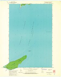
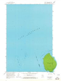 1963 Bear Island1965 Print · USGSThe Apostle Islands are captured in the mid-1960s, showing the remote character of this Lake Superior archipelago. Local historians can trace early trails across Bear Island and study the maritime hazards of Bear Island Shoal.
 - 1963 Map of Rocky Island, 1965 Print
 1963 Rocky Island1965 Print · USGSThe northern Apostle Islands are captured here in the early sixties, showing the isolated maritime and aviation outposts of La Pointe. Researchers can trace navigation aids like the Devils Island Light and the small Landing Strip on South Twin Island.2 unique versions available
 - 1964 Map of Two Harbors
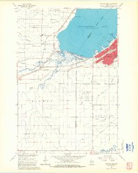
 1964 Two Harbors1964 Print · USGSThe North Shore of Lake Superior is captured here during the mid-1950s, a time of significant industrial mining growth and emerging tourism. Genealogists and historians can trace the rail lines of the Duluth Missabe and Iron Range and locate landmarks like Split Rock Light and the U S Air Force Radar Station.
 - 1964 Map of Ashland West, 1965 Print
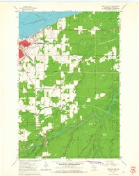
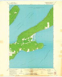
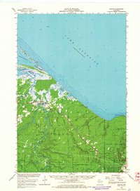
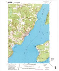
 1964 Ashland West1965 Print · USGSThe Lake Superior shoreline at the mid-century shows the city of Ashland as a vital rail and educational center. Researchers can trace the legacy of the Chicago and North Western lines, local schools like Ondassagon Sch, and the grounds of the University of Wisconsin Experiment Station.4 unique versions available
 - 1964 Map of Ashland East, 1965 Print
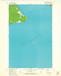
 1964 Ashland East1965 Print · USGSAshland and its lakefront surroundings are captured in the mid-1960s as the city expanded toward the Bad River Indian Reservation. Researchers can trace the mid-century campuses of Northland College and the County Teachers College or locate the old Drive-in Theater.2 unique versions available
 - 1964 Map of Bayfield, 1965 Print
 1964 Bayfield1965 Print · USGSThe Bayfield Peninsula and Apostle Islands are captured in the mid-1960s, showing the intersection of tribal lands and Lake Superior maritime life. Researchers can trace the Chicago and North Western rail line and locate landmarks like the Bayfield State Fish Hatchery and Calvary Cem.
 - 1964 Map of York Island, 1965 Print
 1964 York Island1965 Print · USGSThe Bayfield Peninsula and the Apostle Islands appear here in the mid-1960s, showing a landscape defined by tribal lands and maritime navigation. Trace the borders of the Red Cliff Indian Reservation and locate landmarks like the Light on Raspberry Island.
 - 1964 Map of Madeline Island, 1965 Print
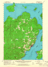
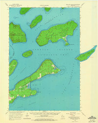
 1964 Madeline Island1965 Print · USGSMadeline Island and its surrounding channels appear here in the mid-sixties, capturing the island's mix of state forest land and local township settlement. Genealogists and maritime historians can trace landmarks like Greenwood Cem, the Quarry, and soundings within Sunset Bay.2 unique versions available
 - 1964 Map of Long Island, 1965 Print
 1964 Long Island1965 Print · USGSThe Lake Superior coast of Bayfield County is captured here in the mid-1960s, showing the vital maritime connection between the mainland and the Apostle Islands. Researchers can locate the navigational La Pointe Light, trace the Chicago and North Western rail line through Washburn, and explore the shoreline from Houghton Point to Oak Point.
 - 1964 Map of Cedar, 1965 Print
 1964 Cedar1965 Print · USGSThe Lake Superior shoreline near the Ashland and Iron County border reveals a landscape of timber and rail in the mid-sixties. Researchers can trace the Chicago and North Western line through Cedar or locate the Birch Ridge Lookout Tower and Waverly Campground.2 unique versions available
 - 1964 Map of Chequamegon Point, 1965 Print
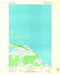 1964 Chequamegon Point1965 Print · USGSThe northern tip of Ashland County meets the open water in the mid-1960s, showing the delicate interface of lake and land. Researchers can trace the winding paths of the Bad River and Kakagon River through the Bad River Slough marshlands.2 unique versions available
 - 1964 Map of Amnicon Point, 1965 Print
 1964 Amnicon Point1965 Print · USGSMadeline Island and the northern reaches of the Apostle Islands are captured in the mid-sixties. Trace shoreline landmarks like Amnicon Point, Devils Cauldron, and the marshes around Bog Lake.2 unique versions available
 - 1964 Map of Ashland, 1965 Print
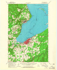 1964 Ashland1965 Print · USGSChequamegon Bay was a bustling hub of maritime and rail transport in the mid-sixties. Researchers can trace the extensive rail lines at Ashland Junction, find local heritage sites like Northland College, and locate family names at St Agnes Cem.2 unique versions available
 - 1964 Map of Odanah, 1965 Print
 1964 Odanah1965 Print · USGSThe northern coast of Wisconsin's Ashland County is captured here in the mid-1960s, centered on the riverfront settlement of Odanah. Local historians can trace the paths of the Chicago and North Western railroad and locate landmarks like Odanah Cem and Pictured Rock Lake.2 unique versions available
 - 1964 Map of Odanah, 1966 Print
 1964 Odanah1966 Print · USGSThe Lake Superior shoreline and the Bad River drainage are captured in the mid-1960s, showing the intersection of rail transit and coastal wetlands. Researchers can trace local history through Odanah, the Odanah Cem, and the Birch Ridge Lookout Tower.2 unique versions available
 - 1964 Map of Madeline Island, 1966 Print
 1964 Madeline Island1966 Print · USGSThe Apostle Islands archipelago is shown here in the mid-1960s, documenting the remote reaches of Ashland County before modern park status. Trace local landmarks like Greenwood Cem, the old Quarry on Hermit Island, and geological curiosities like Balancing Rock.2 unique versions available
 - 1964 Map of Bayfield, 1976 Print
 1964 Bayfield1976 Print · USGSBayfield and the Apostle Islands appear in the mid-1960s just as the region's maritime and forest identities were being preserved. Trace the local history of La Pointe on Madeline Island or locate family sites at Evergreen Cem and Calvary Cem.2 unique versions available
 - 1967 Map of Marengo SE
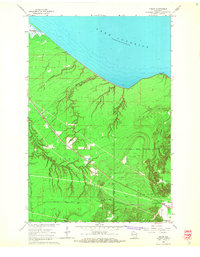
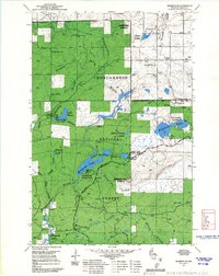 1967 Marengo SE1967 Print · USGSAshland County's timberlands are seen here in the late sixties as the Forest Service managed this active recreational and industrial landscape. Trace the footpaths along the North Country Trail and locate former fire towers at Marengo Lookout and Mineral Lake Lookout.
Showing maps 1-25 of 34
Top cities of Ashland County
- Ashland historical maps
- Mellen historical maps
- Butternut historical maps
- La Pointe historical maps
- Shanagolden historical maps
Frequently asked questions
- What are the different types of historical maps available for Ashland County?
- What is the oldest map of Ashland County?
- Where can I purchase historical maps of Ashland County for my home or office?
- Where can I download high-res historical maps of Ashland County?
- Are there historical topographic maps available for Ashland County?
- Is there historical aerial imagery available for Ashland County?
- Where are historical maps of Ashland County sourced from?