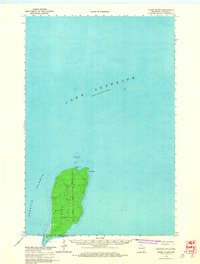
1963 Map of Outer Island
USGS Topo · Published 1965About this map
Outer Island Light stands at the northern tip of the easternmost island in the Apostle Islands chain, marking a critical point for maritime navigation in Lake Superior. This survey captures the island's isolation and its topographic detail, defined by the Fourth Principal Meridian which bisects the landmass. The island's geography features Austad Bay on its eastern shore and the sharp projection of Sand Point at its southern extremity. Beyond the shore, hydrographic data reveals the underwater hazards of the Outer Island Shoal. The map serves as a record of this offshore outpost during the early 1960s, showing the precise township and range boundaries including T 53 N and T 52 N as they relate to the natural landforms of the archipelago.
Find a feature on this map
9 named features on this map. Tap any name to fly to it.
Don’t see what you’re looking for? This feature index may not catch every label — zoom into the map to look around manually.
Map Details
Editions of this 1963 Outer Island Map
2 editions found
Other maps of this area

1953 · Ashland
USGS Topo · 1:250,000

1954 · Two Harbors
USGS Topo · 1:250,000

1957 · Two Harbors
USGS Topo · 1:250,000

1958 · Ashland
USGS Topo · 1:250,000

1958 · Two Harbors
USGS Topo · 1:250,000

1963 · Cat Island
USGS Topo · 1:24,000

1963 · Michigan Island
USGS Topo · 1:24,000

1963 · Rocky Island
USGS Topo · 1:62,500
1963 · Outer Island
USGS Topo · 1:24,000
1963 · Stockton Island
USGS Topo · 1:24,000