1980s Maps of Sanborn, Wisconsin
Explore 5 historic maps of Sanborn from the 1980s. These maps offer a rare glimpse into what life looked like during the 1980s — showing old roads, neighborhoods, homes, and landmarks that have changed or disappeared over time.
Whether you're researching your family's past, planning a metal detecting trip, or studying how Sanborn's landscape evolved across the 1980s, these high-resolution maps are a powerful tool for exploring the history of this region.
- Focus on a specific era: All maps on this page are from the 1980s, giving you a focused view of this time period.
- See what’s changed: Compare century-old streets, trails, and buildings to today's modern landscape using overlays and satellite layers.
- Research with precision: Use these maps for genealogy, historical research, land use analysis, or educational projects.
- View, download, or print: Maps are fully viewable online in high resolution, and can be downloaded or printed for your own records.
Start exploring Sanborn's history through authentic maps from the 1980s. This is your window into the past.
Sanborn, WI maps
(5)- 1980 Map of Ironwood
 1980 Ironwood1980 Print · USGSThe Michigan-Wisconsin borderlands appear in the late twentieth century as a landscape defined by iron mining and deep forests. Researchers can trace the rail-and-river economy through the Soo Line and Chicago and North Western tracks connecting Mellen, Glidden, and Hurley.
 - 1984 Map of Gurney
 1984 Gurney1984 Print · USGSNorthern Wisconsin's timber and rail landscape is captured here in the 1980s as the Soo Line Railroad winds through the Bad River Indian Reservation. Researchers can trace family history through Edgewood Cem or locate old homesteads near Sedgwick and the Potato River Falls.
 - 1984 Map of Marengo
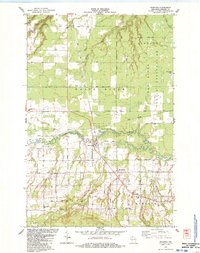 1984 Marengo1984 Print · USGSNorthern Wisconsin's rural landscape is captured here in the mid-1980s, centered on the confluence of the Marengo River. Researchers can locate family landmarks like Maple Grove Cem, St Pauls Ch, and the old Marengo Valley Sch.
 - 1984 Map of High Bridge
 1984 High Bridge1984 Print · USGSAshland County in the mid-1980s reveals a landscape where the river and rail economy shaped the rural township of Morse. Local researchers can find the Soo Line junction at High Bridge, trace family-named roads like Kleinsteiber Road, and locate the old Cem.
 - 1989 Map of Ashland
 1989 Ashland1989 Print · USGSCoastal Wisconsin and Michigan at the end of the 1980s show a landscape of deep-water bays, island preserves, and industrial timber towns. Researchers can trace the rail lines of the Soo Line and identify landmarks from Big Bay State Park to the Bad River Indian Reservation.
End of results
Showing maps 1-5 of 5
Top cities near Sanborn
- Ashland historical maps
- Washburn historical maps
- Sanborn historical maps
- White River historical maps
- New Odanah historical maps
- Marengo historical maps
See more
Top neighborhoods of Sanborn
- Birch historical maps
- Sedgwick historical maps
- Birch Hill historical maps
- Franks Field historical maps
- Diaperville historical maps
- New Odanah historical maps
See more
Frequently asked questions
- What are the different types of historical maps available for Sanborn?
- What is the oldest map of Sanborn?
- Where can I purchase historical maps of Sanborn for my home or office?
- Where can I download high-res historical maps of Sanborn?
- Are there historical topographic maps available for Sanborn?
- Is there historical aerial imagery available for Sanborn?
- Where are historical maps of Sanborn sourced from?