1940s Maps of Sanborn, Wisconsin
Explore 8 historic maps of Sanborn from the 1940s. These maps offer a rare glimpse into what life looked like during the 1940s — showing old roads, neighborhoods, homes, and landmarks that have changed or disappeared over time.
Whether you're researching your family's past, planning a metal detecting trip, or studying how Sanborn's landscape evolved across the 1940s, these high-resolution maps are a powerful tool for exploring the history of this region.
- Focus on a specific era: All maps on this page are from the 1940s, giving you a focused view of this time period.
- See what’s changed: Compare century-old streets, trails, and buildings to today's modern landscape using overlays and satellite layers.
- Research with precision: Use these maps for genealogy, historical research, land use analysis, or educational projects.
- View, download, or print: Maps are fully viewable online in high resolution, and can be downloaded or printed for your own records.
Start exploring Sanborn's history through authentic maps from the 1940s. This is your window into the past.
Sanborn, WI maps
(8)- 1942 Map of Ashland
 1942 Ashland1942 Print · USGSThe South Shore of Lake Superior comes alive in the early 1940s, showing the bustling rail hubs and maritime ports of Chequamegon Bay. Genealogists and historians can trace local family roots through sites like Northland College, St Agnes Cem, and Ondassagon Sch.
 - 1942 Map of Mellen, 1959 Print
 1942 Mellen1959 Print · USGSAshland County and the Iron County border come alive in the early 1940s as a landscape of timber, iron rails, and deep Northwoods lakes. Researchers can trace the path of the Minneapolis St Paul and Sault Ste Marie railroad or locate family sites like Sedgwick and the St Johns Cem.
 - 1942 Map of Marengo, 1964 Print
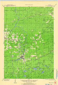
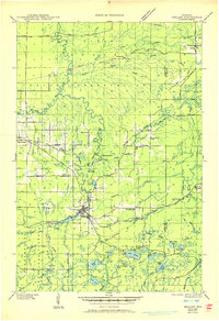
 1942 Marengo1964 Print · USGSNorthern Wisconsin's timber and rail landscape is captured here in the early 1940s, showing the intersection of federal forest land and tribal territory. Genealogists can locate specific rural schools like Maple Ridge Sch and communities like Sanborn or North York.
 - 1943 Map of Odanah, 1952 Print
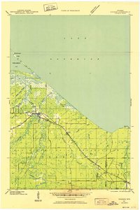 1943 Odanah1952 Print · USGSNorthern Wisconsin's Lake Superior shoreline and the Bad River delta are captured here during the early 1940s. Genealogists and historians can trace the Chicago and Northwestern rail line and local settlements at Odanah, Birch, and Rufus.
 - 1945 Map of Odanah
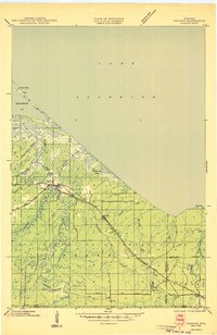 1945 Odanah1945 Print · USGSCoastal Ashland and Iron counties are documented here in the 1940s, highlighting the intricate river systems of the Bad River Indian Reservation. Researchers can trace the Chicago and Northwestern rail line through early settlements like Odanah, Rufus, and Birch.
 - 1945 Map of Marengo
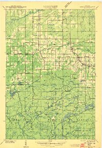 1945 Marengo1945 Print · USGSAshland County and the Chequamegon National Forest are captured here in the mid-1940s, showing a landscape shaped by timber and rail. Researchers can locate rural landmarks like Ebenezer Ch and vanished local schools including Agnew Sch and Section Five Sch.2 unique versions available
 - 1945 Map of Mellen, 1950 Print
 1945 Mellen1950 Print · USGSAshland and Iron Counties come alive in the mid-1940s, showing a rugged landscape of iron-range railways and remote forest schools. Genealogists can trace family landmarks like Coria Sch, St Johns Sch, and the rail junction at Mellen.
 - 1947 Map of Ashland
 1947 Ashland1947 Print · USGSCoastal Wisconsin thrived on the shores of Lake Superior in the late 1940s, balancing industrial power with small-town education. Genealogists can trace family roots through numerous country schools like Olson Sch and local sites like St Agnes Cem.
End of results
Showing maps 1-8 of 8
Top cities near Sanborn
- Ashland historical maps
- Washburn historical maps
- Sanborn historical maps
- White River historical maps
- New Odanah historical maps
- Marengo historical maps
See more
Top neighborhoods of Sanborn
- Sedgwick historical maps
- Birch historical maps
- Birch Hill historical maps
- Franks Field historical maps
- Diaperville historical maps
- New Odanah historical maps
See more
Frequently asked questions
- What are the different types of historical maps available for Sanborn?
- What is the oldest map of Sanborn?
- Where can I purchase historical maps of Sanborn for my home or office?
- Where can I download high-res historical maps of Sanborn?
- Are there historical topographic maps available for Sanborn?
- Is there historical aerial imagery available for Sanborn?
- Where are historical maps of Sanborn sourced from?