
Loading...
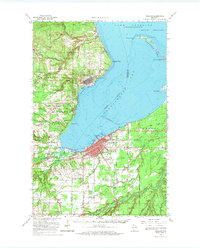
Loading map...1942 Map of Ashland
USGS Topo · Published 1942About this map
Chequamegon Bay serves as the central focal point of this 1942 field examination, illustrating the industrial and maritime character of the South Shore of Lake Superior. The city of Ashland is shown in detail, featuring the campus of Northland College and an extensive network of railroads including the Northwestern and Northern Pacific. To the north, Washburn and the Barksdale area emphasize the region's mid-century infrastructure, notably the Du Pont Power Plant.
Find a feature on this map
57 named features on this map. Tap any name to fly to it.
Don’t see what you’re looking for? This feature index may not catch every label — zoom into the map to look around manually.
Map Details
Date Portrayed1942
Date Published1942
PublisherU.S. Geological Survey
Map TypeTopographic
Scale1:48,000
Physical Dimensions18.9 x 27.4 inches
Editions of this 1942 Ashland Map
This is the sole edition of this map. No revisions or reprints were ever made.
Historical Maps of Ashland Through Time
6 maps found


Featured Locations
Source Details
SourceU.S. Geological Survey
CopyrightPublic Domain