
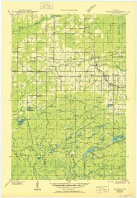
1945 Map of Marengo
USGS Topo · Published 1945About this map
The Duluth South Shore and Atlantic railway cuts across the northern landscape of Ashland County, serving as a primary corridor for the small communities of Sanborn, Marengo, and Minersville. This 1945 edition, based on field examinations from 1942, reveals a rural network of schoolhouses such as Maple Ridge Sch, Argo Sch, and Yderstad Sch that once anchored these townships. The northern half is defined by the White River and the edges of the Bad River Indian Reservation, while the southern portion transitions into the dense woods of the Chequamegon National Forest. The presence of the Marengo Fire Tower and Mineral Lake Fire Tower highlights the era's focus on forest management, while the Lake Superior Power Plant on the northern river indicates early industrial utility in the region.
Find a feature on this map
52 named features on this map. Tap any name to fly to it.
Don’t see what you’re looking for? This feature index may not catch every label — zoom into the map to look around manually.
Map Details
Editions of this 1945 Marengo Map
2 editions found
Other maps of this area

1942 · Ashland
USGS Topo · 1:48,000

1942 · Glidden
USGS Topo · 1:48,000

1942 · Clam Lake
USGS Topo · 1:48,000

1942 · Mellen
USGS Topo · 1:48,000

1942 · Marengo
USGS Topo · 1:48,000

1943 · Odanah
USGS Topo · 1:48,000

1943 · Namekagon Lake
USGS Topo · 1:48,000

1944 · Moquah
USGS Topo · 1:48,000

1944 · Grandview
USGS Topo · 1:48,000

1945 · Odanah
USGS Topo · 1:48,000