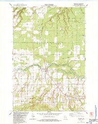
1984 Map of Marengo
USGS Topo · Published 1984About this map
The Marengo River and Brunsweiler River converge in this northern Wisconsin landscape, carving through a region defined by its rural crossroads and agricultural roots. The settlement of Marengo serves as a central hub, anchored by the local Fairground and served by the Soo Line railroad. Further south, the community of Minersville and the tracks of the Soo Line near North York illustrate the industrial and transit corridors that shaped Ashland County.
Find a feature on this map
39 named features on this map. Tap any name to fly to it.
Don’t see what you’re looking for? This feature index may not catch every label — zoom into the map to look around manually.
Map Details
Editions of this 1984 Marengo Map
This is the sole edition of this map. No revisions or reprints were ever made.
Other maps of this area

1942 · Ashland
USGS Topo · 1:48,000

1942 · Mellen
USGS Topo · 1:48,000

1942 · Marengo
USGS Topo · 1:48,000

1943 · Odanah
USGS Topo · 1:48,000

1945 · Odanah
USGS Topo · 1:48,000

1945 · Marengo
USGS Topo · 1:48,000

1945 · Mellen
USGS Topo · 1:48,000

1947 · Ashland
USGS Topo · 1:48,000

1953 · Ashland
USGS Topo · 1:250,000
1956 · Mellen
USGS Topo · 1:24,000