
1944 Map of Cornucopia
USGS Topo · Published 1952About this map
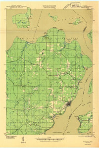
Cornucopia stands as the primary fishing and harbor settlement along this northern Wisconsin shoreline during the mid-1940s. The landscape is defined by the deep indentations of Siskiwit Bay and Bark Bay along the Lake Superior coast, where the Siskiwit River and Bark River meet the cold northern waters. This era shows a community rooted in local industry and faith, evidenced by the presence of St Anthony Ch and the Settlement Sch located southeast of the main village.
Find a feature on this map
24 named features on this map. Tap any name to fly to it.
Don’t see what you’re looking for? This feature index may not catch every label — zoom into the map to look around manually.
Map Details
Editions of this 1944 Cornucopia Map
This is the sole edition of this map. No revisions or reprints were ever made.
Other maps of this area

1941 · Bayfield
USGS Topo · 1:48,000

1942 · Ashland
USGS Topo · 1:48,000

1943 · Port Wing
USGS Topo · 1:48,000

1943 · Iron Lake
USGS Topo · 1:48,000

1944 · Moquah
USGS Topo · 1:48,000

1946 · Cornucopia
USGS Topo · 1:48,000
1946 · Bayfield
USGS Topo · 1:48,000
1946 · Port Wing
USGS Topo · 1:48,000

1947 · Moquah
USGS Topo · 1:48,000

1947 · Iron Lake
USGS Topo · 1:48,000