
1946 Map of Cornucopia
USGS Topo · Published 1946About this map
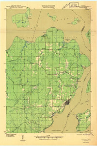
Cornucopia sits as the primary settlement on this 1940s survey of the northern Wisconsin shoreline, where the waters of Siskiwit Bay and Bark Bay meet the sprawling Lake Superior. The landscape is defined by its complex drainage systems, including the three distinct branches of Lost Creek No 1, No 2, and No 3, alongside the larger Siskiwit River. Inland, the map reveals a quiet community structure centered around the St Anthony Ch and the Settlement Sch, reflecting a rural social fabric just south of the lake's edge. The southern portion of the quadrangle transitions into the protected timberlands of the Chequamegon National Forest. Notable coastal landmarks such as Bark Pt and Eagle Island frame the rugged coastline, while State Highway No 13 provides the main artery for transit through the northern woods of Bayfield County.
Find a feature on this map
27 named features on this map. Tap any name to fly to it.
Don’t see what you’re looking for? This feature index may not catch every label — zoom into the map to look around manually.
Map Details
Editions of this 1946 Cornucopia Map
This is the sole edition of this map. No revisions or reprints were ever made.
Other maps of this area

1941 · Bayfield
USGS Topo · 1:48,000

1942 · Ashland
USGS Topo · 1:48,000

1943 · Port Wing
USGS Topo · 1:48,000

1943 · Iron Lake
USGS Topo · 1:48,000

1944 · Moquah
USGS Topo · 1:48,000

1944 · Cornucopia
USGS Topo · 1:48,000
1946 · Bayfield
USGS Topo · 1:48,000
1946 · Port Wing
USGS Topo · 1:48,000

1947 · Moquah
USGS Topo · 1:48,000

1947 · Iron Lake
USGS Topo · 1:48,000