
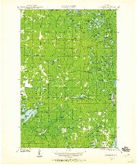
1947 Map of Moquah
USGS Topo · Published 1947About this map
Moquah and Ino anchor this post-war landscape in northern Wisconsin, captured during a period when the timber-driven economy had shifted toward established rural settlements and fire protection infrastructure. The presence of the Moquah Fire Tower and Washburn Fire Tower, along with the Brinks Ranger Sta, highlights the era's focus on forest management across the central and northern townships. Transportation networks define the southern portion of the sheet, where the Chicago and Northwestern railroad parallels the State Highway 2 corridor, connecting the Ino Sta with Benoit further south.
Find a feature on this map
55 named features on this map. Tap any name to fly to it.
Don’t see what you’re looking for? This feature index may not catch every label — zoom into the map to look around manually.
Map Details
Editions of this 1947 Moquah Map
This is the sole edition of this map. No revisions or reprints were ever made.
Other maps of this area

1941 · Bayfield
USGS Topo · 1:48,000

1942 · Ashland
USGS Topo · 1:48,000

1942 · Marengo
USGS Topo · 1:48,000

1943 · Port Wing
USGS Topo · 1:48,000

1943 · Iron Lake
USGS Topo · 1:48,000

1944 · Moquah
USGS Topo · 1:48,000

1944 · Cornucopia
USGS Topo · 1:48,000
1944 · Drummond
USGS Topo · 1:48,000

1944 · Grandview
USGS Topo · 1:48,000
1945 · Marengo
USGS Topo · 1:48,000