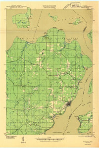
1946 Map of Bayfield
USGS Topo · Published 1946About this map
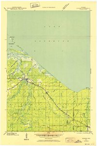
Lake Superior frames the tip of the Bayfield Peninsula in this 1941 field examination, where the Red Cliff Indian Reservation dominates the northern shoreline. The map documents a landscape transitioning from resource extraction to early conservation and health services, evidenced by the presence of a Brickyard near Red Cliff and the Bayfield Fish Hatchery at Salmo. Local social infrastructure is visible through the Sanitarium near Pureair and rural educational outposts like Sand Bay Sch and Carver Sch.
Find a feature on this map
52 named features on this map. Tap any name to fly to it.
Don’t see what you’re looking for? This feature index may not catch every label — zoom into the map to look around manually.
Map Details
Editions of this 1946 Bayfield Map
This is the sole edition of this map. No revisions or reprints were ever made.
Other maps of this area

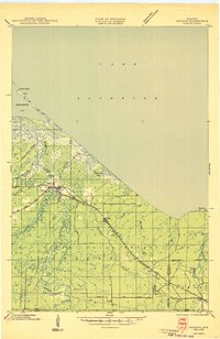
1941 · Bayfield
USGS Topo · 1:48,000

1942 · Ashland
USGS Topo · 1:48,000
1943 · Odanah
USGS Topo · 1:48,000

1944 · Moquah
USGS Topo · 1:48,000

1944 · Cornucopia
USGS Topo · 1:48,000
1945 · Odanah
USGS Topo · 1:48,000

1946 · Cornucopia
USGS Topo · 1:48,000

1947 · Moquah
USGS Topo · 1:48,000

1947 · Ashland
USGS Topo · 1:48,000

1953 · Ashland
USGS Topo · 1:250,000