1980s Maps of Lakeland, Wisconsin
Explore 6 historic maps of Lakeland from the 1980s. These maps offer a rare glimpse into what life looked like during the 1980s — showing old roads, neighborhoods, homes, and landmarks that have changed or disappeared over time.
Whether you're researching your family's past, planning a metal detecting trip, or studying how Lakeland's landscape evolved across the 1980s, these high-resolution maps are a powerful tool for exploring the history of this region.
- Focus on a specific era: All maps on this page are from the 1980s, giving you a focused view of this time period.
- See what’s changed: Compare century-old streets, trails, and buildings to today's modern landscape using overlays and satellite layers.
- Research with precision: Use these maps for genealogy, historical research, land use analysis, or educational projects.
- View, download, or print: Maps are fully viewable online in high resolution, and can be downloaded or printed for your own records.
Start exploring Lakeland's history through authentic maps from the 1980s. This is your window into the past.
Lakeland, WI maps
(6)- 1980 Map of Spooner
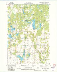
 1980 Spooner1980 Print · USGSNorthwestern Wisconsin at the dawn of the eighties reveals a landscape of deep forests and transitioning rail corridors. Genealogists and historians can trace lakefront settlements like Spooner and Birchwood or follow the early Tuscobia-Park Falls State Trail.
 - 1982 Map of Lower Vermillion Lake
 1982 Lower Vermillion Lake1982 Print · USGSBarron County is a mosaic of glacial lakes and small-town infrastructure in the early eighties. Genealogists and local historians can locate the Section Ten Ch, the Cumberland Municipal Airport, and the Chicago and North Western rail line.
 - 1982 Map of Shell Lake
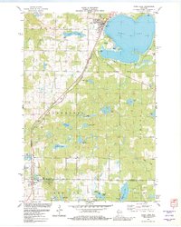 1982 Shell Lake1982 Print · USGSThe Northwoods shoreline of Shell Lake is shown in detail during the early eighties, alongside the southern village of Barronett. Trace local history through the Chicago and North Western rail line and sites like Lakeside Cem and Memorial Park.
 - 1982 Map of Timberland, 1983 Print
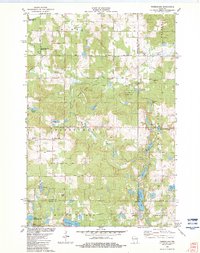 1982 Timberland1983 Print · USGSThe area surrounding Timberland in the early eighties is a landscape of glacial lakes and river forks. Genealogists and local historians can trace the rural communities at Timberland Cem, South Dewey Community Ch, and the Lookout Tower.
 - 1982 Map of Cumberland, 1983 Print
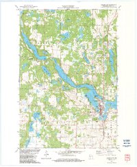 1982 Cumberland1983 Print · USGSCumberland is captured in the early eighties as a unique lake-bound settlement in the glacial north woods of Wisconsin. Genealogists and local historians can trace the town's expansion near Beaver Dam Lake, locating Lakeside Cem, St Pauls Ch, and the Saint Croix Indian Reservation.
 - 1985 Map of Grantsburg
 1985 Grantsburg1985 Print · USGSThe river borderlands of Minnesota and Wisconsin come alive in the mid-1980s, showcasing the intricate water networks and forest preserves of Burnett and Pine counties. Trace the rail lines of the Soo Line or find rural landmarks like Trade Lake Ch and Hildas Corner.2 unique versions available
End of results
Showing maps 1-6 of 6
Top cities near Lakeland
- Rice Lake historical maps
- Barron historical maps
- Spooner historical maps
- Cumberland historical maps
- Cameron historical maps
- Shell Lake historical maps
See more
Top neighborhoods of Lakeland
Frequently asked questions
- What are the different types of historical maps available for Lakeland?
- What is the oldest map of Lakeland?
- Where can I purchase historical maps of Lakeland for my home or office?
- Where can I download high-res historical maps of Lakeland?
- Are there historical topographic maps available for Lakeland?
- Is there historical aerial imagery available for Lakeland?
- Where are historical maps of Lakeland sourced from?