1970s Maps of Prairie Lake, Wisconsin
Explore 4 historic maps of Prairie Lake from the 1970s. These maps offer a rare glimpse into what life looked like during the 1970s — showing old roads, neighborhoods, homes, and landmarks that have changed or disappeared over time.
Whether you're researching your family's past, planning a metal detecting trip, or studying how Prairie Lake's landscape evolved across the 1970s, these high-resolution maps are a powerful tool for exploring the history of this region.
- Focus on a specific era: All maps on this page are from the 1970s, giving you a focused view of this time period.
- See what’s changed: Compare century-old streets, trails, and buildings to today's modern landscape using overlays and satellite layers.
- Research with precision: Use these maps for genealogy, historical research, land use analysis, or educational projects.
- View, download, or print: Maps are fully viewable online in high resolution, and can be downloaded or printed for your own records.
Start exploring Prairie Lake's history through authentic maps from the 1970s. This is your window into the past.
Prairie Lake, WI maps
(4)- 1978 Map of Barron, 1979 Print
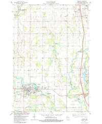 1978 Barron1979 Print · USGSBarron and the surrounding townships are captured in the late seventies, showing a landscape defined by the winding Red Cedar and Yellow Rivers. Researchers can locate the Soo Line rail corridor, the Swede Cem, and the County Museum near the heart of Barron.
 - 1978 Map of Rice Lake South, 1979 Print
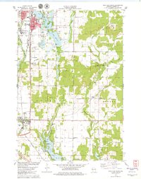 1978 Rice Lake South1979 Print · USGSBarron County in the late seventies shows a landscape of lakefront growth and rural tradition centered on the Rice Lake corridor. Genealogists and local historians can trace family sites at St Joseph Cemetery or the Pioneer Rest Cemetery, and locate vanished landmarks like the Drive-in Theater.
 - 1978 Map of Chetek, 1979 Print
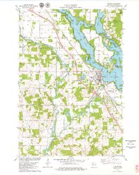 1978 Chetek1979 Print · USGSBarron County’s lake country is captured here in the late seventies, showing the intricate intersection of the Chetek River and the Chicago and North Western rail line. Researchers can locate family landmarks like Otterholt Cem and Pittmans Point among the many island-dotted bays.
 - 1978 Map of Dallas, 1979 Print
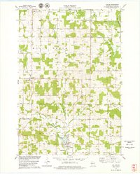 1978 Dallas1979 Print · USGSIn the late seventies, this portion of Barron County shows a quiet landscape of dairy farms and river bends near Dallas. Genealogists and local historians can trace family plots at Old Hillsdale Cem or follow the path of the Old Railroad Grade.
End of results
Showing maps 1-4 of 4
Top cities near Prairie Lake
- Rice Lake historical maps
- Bloomer historical maps
- Barron historical maps
- Chetek historical maps
- Cameron historical maps
- Arland historical maps
See more
Top neighborhoods of Prairie Lake
Frequently asked questions
- What are the different types of historical maps available for Prairie Lake?
- What is the oldest map of Prairie Lake?
- Where can I purchase historical maps of Prairie Lake for my home or office?
- Where can I download high-res historical maps of Prairie Lake?
- Are there historical topographic maps available for Prairie Lake?
- Is there historical aerial imagery available for Prairie Lake?
- Where are historical maps of Prairie Lake sourced from?